

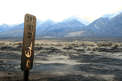
- All State Parks in Big Sur Area Closed Due to Highway 1 Road Slip Out - 04/01/2024
- Giveaway Alert - 03/20/2024
- Climbing Bolt Prohibition in National Parks - 03/19/2024
Veteran High Route guide Doug Robinson and company pay tribute to the long, lost tracks of Otto Steiner
Story and photos by Doug Robinson

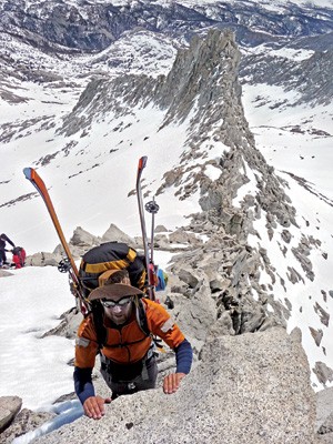
Jay Kumar on the sweet East Ridge of Midway Mountain. This was the opening move, where our Otto Route veered of the classic Sierra High Route.
We’re backing down the north face of Mt. Stanford, kicking soft, loose steps, and I’m scared. Not that Michael Thomas, right above me, will lose it and take me out on his way down – though that’s possible. This one, crossing over the last huge peak, was supposed to be easy. Instead, it went vertical breaching the cornice, and the steepness below, pretty unrelenting, still makes me squirm. Clearly, that photo we were banking on was taken somewhere else.
An unsettling question lurks in the depths. Will it slide? Will the whole face sigh as it submits to gravity, crumpling around us? I think back to waltzing into my first steep Sierra gully on Matterhorn Peak back in the ‘60s. Floundering upward in loose snow, skis long since abandoned. Then we roped up, now we do without. Really, it’s equally useless either way. That day we hadn’t the sense to worry about it avalanching. This time we’ve scouted and seen big spontaneous releases a canyon over, and talked for hours with Sue Burak, the backcountry avalanche forecaster in Mammoth. Unusual sliding layers are threatening us with hidden depth hoar and slick crusts long-buried since January. But it’s getting late. Time to get off this nearly 14,000-foot peak. We suck it up and commit, shadowing the edge of a rock ridge as we descend. How did it come to this?
You’ve all heard of the Sierra High Route, right? Best-known ski tour in the Sierra, ever since Dave Beck led its first traverse in 1975. David was the leading ski guide in this whole range when the big nordic ski boom came along in the ‘70s, perfectly positioned after leading cross country tours through the awesome trees on the Sequoia National Park side of the crest.
I followed Beck across the next spring guiding my own group, and got hooked. Now I’ve traversed the High Route a dozen times or more and, riding the crest of our surge in backcountry skiing, written it up for several magazines. “It’s all marketing,” my ex- once said, before she quit marketing herself to me, and in that enthusiasm I called this tour the High Route of the Americas. Not to be out-hyped, Outside magazine upped the ante to “best ski tour on the planet.”
The Sierra High Route really is that good. Terrain, snowpack and weather all collude. Legendary guide Alan Bard reckoned there were four ranges on the planet where all three ingredients pushed the spring skiing into the running. After sampling them, and after beginning to nudge us all in the direction of shorter, fatter skis, Alan pronounced the High Sierra to be the king range. I’ve travelled a bit myself – skied the namesake Haute Route through the Alps and even pushed my skis to within 10 miles of Everest – and I can only agree. With a smile. No, make that a broad grin, as I pack a Hawaiian shirt to jump on the High Route one more time.
Mayday! Mayday! The rites of spring are upon us. Everyone else is so over skiing, they’re stacked up in the fast lane homing in on the beach in Santa Cruz. Excellent time to reverse commute, sneak out of my home in Surf City™ and head for the alpine zone.
Oops … what are the intrepid ski mountaineers up to now? Could they be cowering in pouring rain, tucked under the covered porch of the nature center in Sequoia National Park, unwilling to face this deluge in the campground like dozens of fearless family campers?
As they pack up and dry out their gear strewn about the Wolverton parking lot, who should appear, likewise heading onto the High Route, but Craig Dostie, the founder of Couloir magazine. Obviously the cognoscente agree that up this high, May is the best season to put ski to snow.
Not to complain here, because the High Route is simply uncanny in the way its line strings together one stretch after another of perfect bowls as it chases this high divide across the range. But, well, let’s say it all started with noticing the tantalizing slopes of Midway Mountain. See, half way across it teeters over its high point on the 13,200-foot shoulder of Milestone Mountain. Then the High Route drops off the Kings-Kern Divide heading for the rolling terrain of the Tyndall Plateau to exit over Shepherd Pass. I took a photo of Midway’s huge open slopes – never been skied – and over the years the shimmering spring corn in that snapshot kept surfacing in my dreams.
I waited a decade – no, more – for the right team. Michael Thomas is the dream client, so strong I could take him on the first ascent of Lost, an 18-hour, 20-pitch marathon, edging toward 5.10 up the unclimbed SW quadrant of Mt. Whitney. When I collapsed into the summit shelter at four a.m., pleading for a nap, Michael shouldered the rack and rope, hiked out to Whitney Portal by dawn and drove back to work. (More unclimbed ridges await right next to Lost; I taunt you.) If anything, Michael is an even better skier than climber, gleefully launching himself down steeps where I fully hedged, clutched my ice axe and kept kicking steps. Then there’s Jay Kumar. Jay showed up in my climbing class at Foothill College, then segued into an apprentice guide. Ever the dirtbag, Jay found a second-hand pair of second-string skis on Craigslist, complete with bindings for $50. He proceeded to fully tear up the place.
In the weeks before we pulled out of Wolverton, the western roadhead, Jay and I had scouted in from the east over Kearsarge Pass, spying on the highest reaches where no one seemed to know much about the Kings-Kern Divide, especially on skis. We had left two food caches. And I was freshly down from placing a first camp with more food and fuel up ahead of us on the Tablelands. It wasn’t so much that our 10-day trip would be a mini-expedition, but the fierceness of the terrain, where we launched over and around eight more peaks that all grazed 14,000 feet, gave us real pause.
Cruising the start, on the so-familiar High Route, it was cool to meet parties streaming across from the east. The big news by 2009 was the way folks were ripping it up. Fat skis and stout boots have emboldened skiers to make tracks on virtually every gully and smooth face that could be reached from the High Route. Beautiful tracks, shredding tracks, tearing-it-up tracks. We had our own moment the morning we tilted into Deadman Canyon. Throw off the pack, submit to gravity. It is billowing terrain, huge succulent rolls that invite abandon. The corn is silky, yes, hissing under our tips as our edges dig into the next broad arc. Wings of glass.
I was glowing with pride for what backcountry skiing has become. Clearly the times were ripe to up the ante by venturing to follow the crescendo of this, the most rugged of all the east-west divides in the High Sierra.
The weather had turned stunning. We never pitched our tent, sleeping night after night in the open. And day after day our biggest threat was sunburn. Well, there was also the dark cloud of blisters from Michael’s new boots. Jay and I turned away squeamishly from his hamburger heels, sure the trip would abort. Somehow he hung tough. Anyway, who could walk away from this sweet snow?
The phantom member of our team was Sue Burak. She’s the backcountry avalanche forecaster for the Eastern Sierra, based in Mammoth. Her bread and butter is educating backcountry skiers who launch themselves, often cluelessly, into the Sherwins above town. But Sue’s heart tugs to the heights of the Sierra Crest, and in the run-up toward our trip I would buy her dinner at Toms Place, the rustic resort hamlet off 395 at the mouth of Rock Creek Canyon, to pick her brain about the quite unusual hazard layers lurking in the high north-facing gullies. She could not quite pull away from analyzing snow pits and writing forecasts to come along with us. And those anomalous, threatening conditions of 2009 — more reminiscent of Colorado than California — are becoming a scientific paper.
Halfway across, Milestone Mountain is a kingpin. All over the southern Sierra you can see its distinctive summit shaped like a flat-topped desert spire perched atop its peak. There we diverted off the High Route, eager to climb into that snapshot of Midway Mountain. Timing is everything, and that day we missed the window for perfect corn, settling for great second-class clambering up its eastern ridge, went right over the 13,666’ summit to a glory run that stretched for miles down the west face. We had arrived on the Otto Route.
David Beck wasn’t the first. Nearly 50 years before, Otto Steiner kicked into his bindings and headed east. He was a nordic ski racer from Austria, a champion. One of the best of Europe. A handful of them were imported to fuel an early surge in North American skiing in the 1930s. His cohorts found the sites of Sun Valley and the great ski fields of the Canadian Rockies. Those places just happened to be convenient to the transcontinental railways that just happened to be paying their salaries.
Otto Steiner was the first to ski up onto the perfect sweep of the Tablelands, marveling at the wide-open terrain. His wooden nordic skis were light and skinny and springy and his rucksack held little more than a primus stove and a scattering of cross country waxes. Three days later he was over most of what’s now the High Route and down on the Kern River, soaking in the hot springs. No fool that boy. Tomorrow maybe he’d glide over toward Mt. Whitney before turning back to Wolverton. Two High Routes, one out and one back, without bothering in between to descend to civilization east of the Sierra. All alone.
Otto Steiner is nearly forgotten. I have David Beck to thank for pointing him out, though Beck’s guidebook Ski Touring in California, still the best ever written, is long out of print.
The first three peaks of our new line remind me of starfish, with long, cliffy ridges for arms. The arms stretch east and west as the divide trends north. Hence we cut a long eastern meander just to get onto the face of Midway, then a two-mile westerly diversion to finally clear the end of another of its arms and start back up toward Table Mountain. Totally flat on top. Total cliffs for sides. We skied past it to the west, finally catching a break under the northern leg of the table. I’ll call it Turntable Col. It led to the first of our drops down northerly chutes, squeamish of stability. We bivied high again, on rolling slab again, under enticing unclimbed walls again, in a canyon with no name.
Two days later we arrived on this north face of Mt. Stanford. Actually we’re on the east face of its north ridge. I’ve spent enough time picking apart the journals of California explorers — going all the way back to a three days crossing of the Big Sur mountains in the tracks of a single paragraph from Portola’s journal of 1769 — to know that accuracy counts. Michael can’t stand it any longer. He’s up on his skis, cutting great arcs across the steep face, leaving a rooster tail of damp snow. Power skiing. It is truly awesome to watch. Within seconds he’s 700 feet below us.
We pull up to camp on the flat top of a giant boulder. It’s our throne room in a sea of white. We break out the Scotch to celebrate. Tomorrow’s trajectory is laid out before us, a series of bowls so perfect they dwarf any ski area on the continent. We will swoop across the John Muir Trail in a blink as it picks its way unseen over a rocky landscape still smothered in white. Then on to kiss the flanks of Junction Peak, sealing our traverse where the Kings-Kern Divide meets the crest of the Sierra.
The North Face of University Peak the day after will be icing on this cake, though truly we are so tired that clawing our way over its west ridge is a bleary effort. Finally the inevitable willow thrash and dinner at Still Life – how can this be? – the finest French restaurant for 200 miles in the tiny desert town of Independence.
The classic High Route was born perfect. The way it unfolds terrain is so natural, effortless. It flows. Our new Otto Route, on the other hand, is gnarlier. We ended up doing about double the High Route in days, elevation gained (and — yeah bro! — lost), in effort and commitment and seriousness. It definitely crossed the rope-and-ice-axe line into ski mountaineering. The Otto Route can look forward to 50 years of fine-tuning. Even big variations. It has long open beautiful slopes, sure. But some of them slide right by an entire peak, or even three, of the Divide we’re weaving. Every time you turn around there’s the suggestion of another steep gully slashing through jagged terrain that has never felt the bite of a ski edge.
Have at it. I can’t wait to see this one evolve.


