

- All State Parks in Big Sur Area Closed Due to Highway 1 Road Slip Out - 04/01/2024
- Giveaway Alert - 03/20/2024
- Climbing Bolt Prohibition in National Parks - 03/19/2024

One-stop hotspots to green up your multi-sport adventures
Story and photos by Seth Lightcap
Despite California’s empty wallet, the Golden State is not hurting for amazing outdoor recreation opportunities. From the redwoods to the Sierra and back to the Bay there is an adventure lurking along every highway.
Surrounded by all these beaches, trails, rivers, and crags, the diversity of natural amenities makes it easy to do it all, if even in a single sunny day. Care to kayak then pedal singletrack? Or how about a road ride and then some bouldering? … Double-up days like these are no problem in the rich and diverse landscapes of our greater Nor Cal/Nevada region.
But just like a buffet table with endless options, sometimes the spread of available activities can coerce us into a few too many return trips. Or in this case, a few too many excuses to jump in the car and drive.
With the gas pedal unavoidable in most of our daily lives, eliminating unnecessary time in the car on a play day is obviously desirable. Yet, many of us find ourselves spending too many hours on the road and burning too much gas heading to and fro our otherwise low-impact outdoor activities.
Take a second to think about the miles you drive in your typical adventure routine. Could any be cut out?
Connecting the dots on certain activities and destinations will likely require some drive time but you might be surprised how easy it is to reconfigure your routine, or create a new one, that weans you off undue overdependence on the steering wheel.
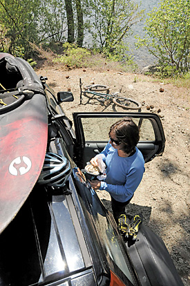
The goal: Park once, play twice, or thrice … however many activities you can squeeze in … without having to start the engine inbetween.
Using a little creativity and forethought, pinpoint a parking spot within striking distance of a smorgasbord of your favorite activities. You might have to pedal a touch farther, or hike a little longer to make it work, but isn’t that what you’re out there for anyway?
It’s the little things that count in our battle to decrease energy consumption and though cutting out a short drive down the road may seem trivial, the savings do add up.
To inspire your new greener adventure activity plans, we’ve come up with some suggested one-stop destinations where turning off the engine in the morning and forgetting about it until dark is easy. There are, of course, countless more … Keep track of your keys though. You’ll need those to access your gear chest throughout the day.
Donner Lake
Where to park: Coming from Truckee, one of the best free spots to park and play all day is at the east end of the lake just past the Donner Memorial State Park entrance on the south side of the road. Look for a collection of semi-beat up Subarus and Toyotas; this is a popular dislodging point for locals. Or you can pay to park in the state park and avoid the side-of–the-road show.
What to bring: Kayaks, paddleboards, hiking boots, mountain bikes, road bikes, climbing shoes, bouldering pads, goggles, swim suit, lunch.
What to do: Donner’s sparkling water may be the foremost attraction but the singletrack trails and boulders hidden on its southeastern shore are equally inspiring. You’ll find miles of easy-access MTB and hiking trails littered throughout the state park and several epic dirt rides just out of the park boundary. Roadies can climb up to Donner Summit on Old Hwy 40 (a three-mile climb) and head west toward Soda Springs. Climbers should finish their day stretching out on the moderate boulder problems of Split Rock, a gianormous cracked egg of granite adjacent to the park campground.
Where to refuel: There are many within pedaling distance, actually, the entire town of Truckee is within pedaling distance, but you may want to pack a picnic. You won’t want to leave the lakeshore until the sun sets. Florian’s, a wine and specialty food store next to Safeway, makes hearty sandwiches to go for $5 and offers a tantalizing selection of microbrews to wind up your day.
Commons Beach, Tahoe City
Where to park: Parking in Tahoe City can be tricky on busy days but Commons Beach is a good bet if you get there in the morning. Otherwise look streetside.
What to bring: Kayaks, paddleboards, sail boats, mountain bikes, road bikes, and rock climbing gear.
What to do: Big Blue makes it pretty obvious — paddle/sail/swim till your sun burnt or arms hurt, then go biking, or climbing or both. You can toss a boat in the water just about anywhere and the best trails are just above Tahoe City in Burton Creek State Park and along the Tahoe Rim Trail. Roadies can head to Homewood and beyond. Unknown to most, worthy top-rope rock climbing is also just a hop-skip away from the lakeshore at Twin Crags. Pedal out of town on Hwy 89 north and look for Twin Crags Road on your right in a mile or so. Climb a short distance to the gate, lock up the bikes, and head up the trail to the crags.
Where to refuel: No worries here. Tahoe City is ripe with great food. For a quick bite try Java Juice Wrap or Syd’s Bagelry. Both are just above Commons Beach.
Westside, Santa Cruz
Where to park: Non-metered non-permitted parking in downtown Santa Cruz is hard to come by, but you may have some luck streetside above Cowell’s Beach along West Cliff Drive. The goal is to park close enough to the ocean to casually access the beach with water toys. Good luck on a weekend. An early rise improves your chances considerably.
What to bring: Kayaks, paddleboards, surfboards, skateboards, BMX bikes, mountain bikes, road bikes, volleyballs, and flip flops, of course.
What to do: Cowell’s Beach is home to one of the best beginner surf breaks in the world, but is commonly overcrowded on weekends. Escape the beach activities by jumping on your bike of choice. BMX rippers will spy an old wooden skate park across from the boardwalk that’s been transformed into a bike/skate park. Roadies can head north on Hwy 1. Mountain bikers can trail the roadies and head toward Wilder Ranch or chase along the downtown bike path toward the UCSC campus trail network. Finish the day ripping the skatepark that’s three blocks off the beach, playing a game of sand volleyball, or get into the ex-“scream” scene by riding the Giant Dipper, the Boardwalk’s famous wooden rollercoaster.
Where to refuel: Burritos and cotton candy aplenty at the Boardwalk. Walk or pedal five minutes to Pacific Avenue and many more non-touristy culinary options present themselves.
Crissy Field, San Francisco
Where to park: East Beach lot, if you’re toting watersports gear, or outer fringe of the Sports Basement’s Presidio store parking lot off Mason Street for runners and cyclists. No parking or entrance fees but lots (particularly East Beach) can fill up quickly. Forgot something? Sports Basement’s enormous selection is there if you need energy snacks, a fresh pair of running shoes, a bike tube or an entirely new ride.
What to bring: Running shoes, road bikes, mountain bikes, kayaks, paddleboards, windsurfer/kitesurf gear (if you’re an expert).
What to do: Crissy Field, part of the Golden Gate National Recreation Area, is one of the most spectacular interfaces of urban and wild places on the globe. It provides a hyperkinetic view of the bay, the Golden Gate Bridge, Marin Headlands, Alcatraz and Angel Island, and the constant movement going on on land, water and in the air. It’s an inspiring blend of vibrancy that makes you want to run off toward Fort Point and maybe Baker Beach, or hop on your mountain or road bike and pedal across the bridge to Marin. Strong paddlers in sea kayaks, surf skis and outriggers can paddle along the shoreline east and west, or venture out in the bay if they’re experienced and knowledgeable about tides, fog, sailing regattas and tanker lanes. Of course, for expert windsurfers and kitesurfers this spot is world famous for its wind, beauty and challenge.
Where to refuel: In the immediate vicinity, Crissy Field Center (at Mason and Halleck streets, but moving to temporary structures at the east edge of Crissy Field by end of September) has a small café with sandwiches and coffee. The Warming Hut out by the fishing pier on the way to Fort Point has food as well. Many more intriguing options on Chestnut Street, a half mile east and off the water. The Grove, at the corner of Chestnut and Avila Street, is a popular open-window café/wi-fi hot spot that serves hearty breakfasts, lunch fare, and casual dinners.
Lake Natoma, Sacramento
Where to park: Nimbus Flat State Park, just off Hazel Avenue and Highway 50, across the cove from the CSU Sacramento Aquatic Center. Day parking permit $7.
What to bring: Running shoes, road bikes, kayaks, paddleboards, rowing shells, swimming wetsuits, goggles, swimcap.
What to do: Long, narrow Lake Natoma is a dammed stretch of the American River. It’s one of the best places in the nation for flatwater paddling and rowing, the site of many elite-level crew competitions and a great place for training. It’s also an ideal spot for staging your own personal triathlon. It’s a popular lake for swimming and an ideal spot for staging your own personal triathlon. Be prepared for chilly water temps since the water is released from the botttom of Folsom Dam. For cycling and running, the American River Parkway trail runs through the park, 33 miles from downtown Sacramento to Folsom Lake.
Where to refuel: For those on bikes, the Coffee Republic in Folsom (6610 Folsom-Auburn Rd. in the Folsom Pavillions Shopping Center) is convenient to the American River bike trail and a popular stopping point for riders. It serves good sandwiches and has casual outdoor seating. Dos Coyotes Border Cafe (13385 Folsom Blvd.) has truly fresh Tex-Mex and is also convenient to the bike trail. If you must, there are also several fast food options across Hazel from Nimbus Flat State Park.


