

- All State Parks in Big Sur Area Closed Due to Highway 1 Road Slip Out - 04/01/2024
- Giveaway Alert - 03/20/2024
- Climbing Bolt Prohibition in National Parks - 03/19/2024
A Paddler’s Guide to California Classics
By Roger Schumann
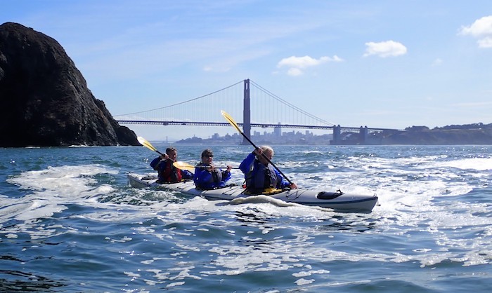
Beginners and advanced paddlers alike can enjoy a safe and exciting guided tour under the Golden Gate Bridge with Sea Trek. Photo: Sean Morley / Sea Trek
Whether you prefer to paddle securely seated in a kayak or favor the enhanced view and balance challenges while standing tall atop an SUP, or both, California offers an outstanding variety of world-class waterways to explore.
From renowned seashores to picturesque Sierra lakes, many of the state’s classic paddling destinations conveniently have rental and tour operations nearby. They are suitable for giving first timers and dabblers a nice taste of the wild and scenic nature that makes each unique. More experienced paddlers with their own boards or boats—along with the skills, gear, and savvy to do so safely, can venture further afield to experience the full flavor of the watery best.
Assessing Skill Levels
Like whitewater rafting, skiing or rock climbing, paddling has its own rating systems, such as the five-level system used by the American Canoe Association, the nation’s largest organization for training and certifying recreational paddlers and instructors.
- Level 1 Paddlers stick to calm, protected areas near shore. If the wind begins to blow or the water gets rough, they head straight back to the beach. They haven’t learned deep-water rescues yet, so in the case of a capsize (or falling off their SUP), their safety depends on staying within easy swimming distance of an easily accessible landing area.
- Level 2 paddlers have practiced basic capsize recovery techniques and board remounts, can handle a little wind (if blowing them in a “safe” direction) and choppy water, but if whitecaps start to form, they know how to head for protection.
- Level 3 paddlers are ready for longer, more-committing journeys further from shore, including crossings of bays or to islands up to a mile from shore in wind, small waves (less than knee high if standing or shoulder high to a kayaker). They’re also comfortable and practiced performing rescues in L3 conditions.
- Level 4 and 5 paddlers enjoy more-exposed areas and double-black-diamond seas, and are prepared to roam a mile or more from shore or between accessible beaches. Like backcountry skiers and snowboarders, they have specialized safety training and equipment allowing them to access difficult terrain and deal with the inevitable avalanches of water they may encounter. Instead of beacon, probe and shovel, they bring along stuff like helmets, dry suits, marine radios, chart and compass. They’re comfortable paddling and performing rescues in L4 or L5 conditions (i.e., currents faster than they can paddle against, large swell and breaking surf from waist to head high or more (well overhead to a kayaker!), all while doing complex on-water navigation.
Lake Tahoe
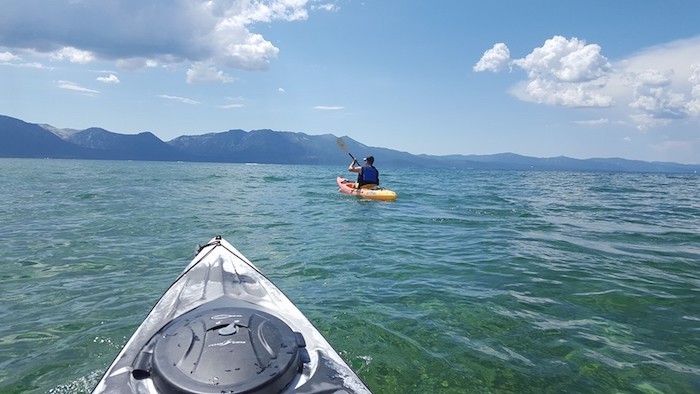
Lake Tahoe is a paddler’s paradise for both stand up paddling and kayaking – rentals and tours are available at various locations around the lake. Photo courtesy of Kayak Tahoe
Tahoe has amazing crystalline blue water surrounded by snowy peaks. There are various launch spots all around the lake as part of the Lake Tahoe Water Trail, with rentals and tours available in many locations. Sand Harbor on the northeast side (ok, technically Nevada, not California) is one of the most scenic on the lake. Another extra-scenic location is Emerald Bay on the southwest corner. Check out Kayak Tahoe for rentals and tours, or for those with at least Level 2 or 3 skills you can paddle there by heading north from Baldwin Beach (two to three miles each way) or south from DL Bliss State Park.
Mendocino Coast
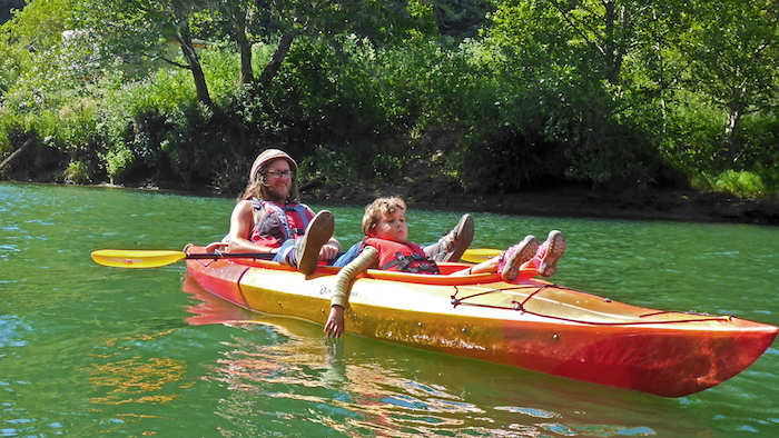
Family fun kayaking on Fort Bragg’s Noyo River. Photo: Liquid Fusion Kayaking
The Mendocino Coast is as wild and scenic as any seashore in the state. Beginners can take a tour or rent kayaks and/or SUPs to explore upstream into the quiet grandeur of the coastal rainforest on both the Noyo River in Fort Bragg, the Big River in Mendocino and the Albion River, south of Mendocino. (Liquid Fusion and Catch a Canoe). While generally a fairly calm, Level 1 or 2 paddle upriver, if you’re going on your own, be sure to check the weather report and tides; plan to paddle early to avoid the typical afternoon sea breeze and pick a day with an ebbing tide on your way back. Trying to return against both wind and current in the afternoon after an easy morning being pushed upriver can be no fun—unless your idea of fun involves battling downriver for hours or possibly spending the night shivering in the bushes along the river bank until dawn.
Taking in the view from a sea kayak in Mendocino. Photo by Roger Schumann
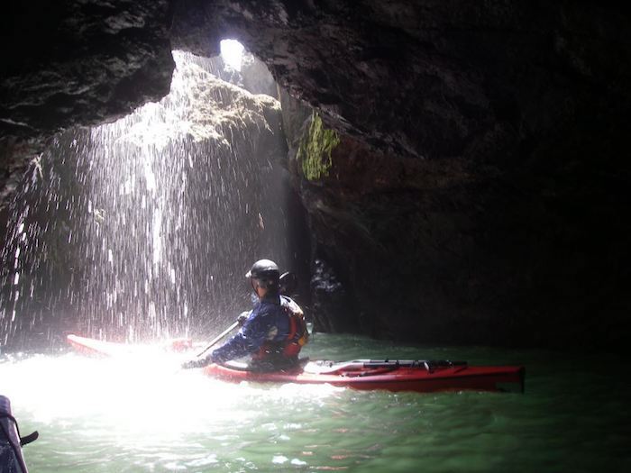
As cool as these rivers can be, what puts Mendo near the top of many paddlers’ local bucket lists is the plethora of sea caves, arches and tunnels. Guided kayak and SUP tours into the sea caves are available from the beach at Van Damme State Park (from Kayak Mendocino and Standup Paddle Mendocino). This is also the best place for those with their own craft to start exploring Mendocino. While generally a Level 2 paddle most mornings, be aware that the cove at Van Damme can get rough on big wind or big swell days. And while paddling beyond the limited protection of Van Damme cove promises some of the best sea cave and rock garden adventure paddling on the planet, it’s not at all beginner friendly. Conditions can change from Level 2 to Levels 3, 4 and 5 in a heartbeat, and as the saying goes, “Waves in caves make graves.” For those with the requisite skills (or with experienced local guides or expert paddling buddies), the seven-mile stretch from Van Damme to Albion Cove is an advanced-paddler’s dream.
Tomales Bay
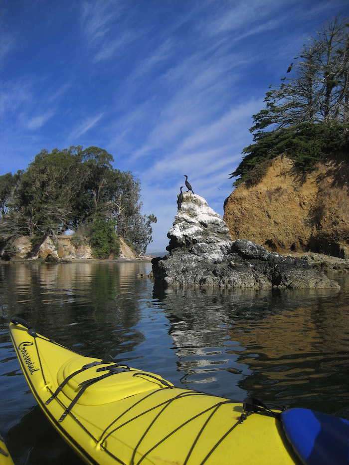
Viewing double breasted cormorants in Tomales Bay. Photo courtesy of Point Reyes Outdoors
That Tomales Bay is bordered by the northern end of the Point Reyes National Seashore hints at the special significance of this local gem. Nestled in the 14-mile-long lee of Inverness Ridge, the bay is famous among local paddlers for offering relatively easy access to miles of rugged, but sheltered, largely uninhabited shoreline with by far the best coastal kayak camping in the state. It’s where most Bay Area sea kayakers take their first overnight camping trip. Take a day or overnight tour with Point Reyes Outdoors, rent from Blue Waters Kayaking in Inverness or go it on your own. Beware the big waves and strong currents at the mouth of the bay unless you are Level 4 to 5, and have a blast playing rough out there if you are.
 For those into downwinding on their SUPs, Tomales Bay is legendary. The prevailing northwest afternoon winds typically funnel into the mouth of the bay and rush straight down its narrow, shallow channel for miles and miles at a dependable 15 to 25 knots, creating an exhilarating one-way roller coaster ride of surfable wind waves. Where to leave your shuttle vehicle is your main decision: 3.5 miles from a launch site at Lawson’s landing at the mouth to the first take out at Nick’s Cove, or another three miles from Nick’s to Marshall, or the full 11 miles all the way to Inverness?
San Francisco’s Golden Gate
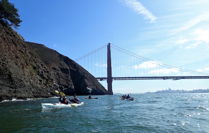
A group of kayakers paddling beyond the Golden Gate Bridge and along the Marin Headlands on one of Sea Trek’s “Paddle the Gate” guided tours. Photo by Sean Morley / Sea Trek
Paddling around with the iconic bridge in the background—or perhaps towering overhead—is a heady experience. Dabblers can take a tour or rent kayaks and SUPs from Sea Trek on the Sausalito shore, which features all the rewards and challenges of the greater bay—scenery, tidal currents, exposure, boat traffic, fog, and wind—in a more protected setting. More experienced paddlers can venture out toward “the Gate” (the waters in the general vicinity of the bridge) or cross Raccoon Strait to Angel Island for a day trip or overnight camping. Besides the distinct possibility of howling winds and ebb tidal currents sweeping you toward the open Pacific at speeds up to twice as fast as you can paddle, the waters beneath the bridge are infamous for being unforgiving. You really need to pick your day carefully and to know what you’re doing or go with someone who does. But for those who do, the three-mile, each-way paddle out the Gate along the Marin Headlands for a peek at the wild, open sea beyond Point Bonita is another top-of-the-bucket-list adventure.
Monterey Bay Area
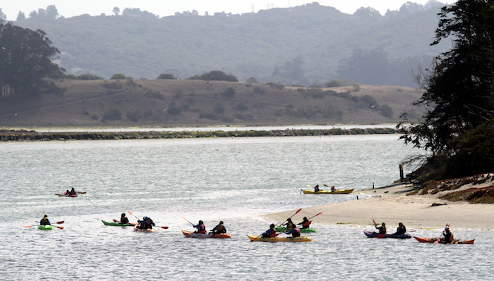
Paddling the slough. Photo courtesy of Monterey Bay Kayaks
Bursting with sea life from the prolific microplankton blooms that fuel the food web to the giant whales and alpha predators at the top, acclaimed for the stunning beauty of its seascapes, the Monterey Bay area is a showpiece of the National Marine Sanctuary Program. At the heart of it lies Elkhorn Slough National Estuarine Reserve, snaking seven miles up a low, coastal valley, full of marine life and paddlers. Relatively well protected, it is among the most popular paddling locations in the state. On summer weekends there is a constant flow of tours and rentals from the two paddling shops near the mouth (Monterey Bay Kayaks and Kayak Connection; yes, both rent SUPs as well). Yet as you paddle into the slough, people spread out and thin, and it still feels wild, as paddlers are vastly outnumbered by sea otters, seals and countless seabirds whirling and diving in frequent feeding frenzies.
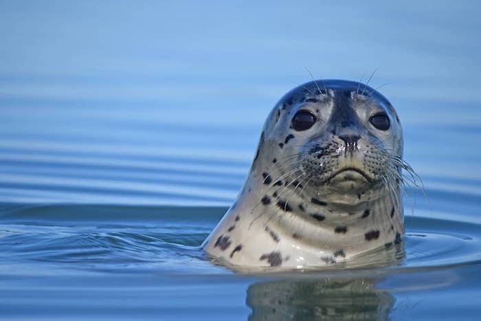
A curious harbor seal. Photo Emma Levy / Kayak Connection
Elkhorn Slough is a great destination for family adventures. Photo: Blue Water Ventures
Beginners also flock in lesser numbers to Monterey Bay Kayaks’ original location on Cannery Row in Monterey, and to Kayak Connections’ site in Santa Cruz Harbor. Experienced paddlers can paddle out the mouth of Elkhorn Slough onto the open bay, and, if not careful, right into the lunge feeding mouth of a whale! Humpback whales frequent the waters over the Monterey Submarine Canyon that start just beyond, sometimes feeding within a few hundred yards of the jetties, although more commonly, a mile or two out.
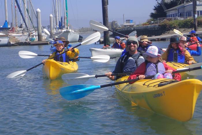
Morro Bay Area
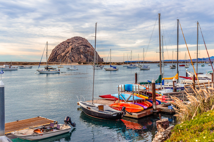
This page, top to bottom: Morro Bay Harbor. Photo courtesy of Visit Morro Bay
Kayak and SUP rentals and tours are available in the distinctive dome-shaped shadow of Morro Rock, another coastal estuary well-known for its prolific birdlife, otters and seals. Further south, Central Coast Kayaks in Shell Beach rents boats and boards, and runs tours to the Dinosaur Caves. Not exactly Mendocino, but pretty cool and relatively easy to access. Those with skills and their own resources can paddle from Eldwayen Ocean Park in Shell Beach, just north of the Dinosaur Caves, or head a couple miles up to Avila Beach, passing another set of caves near Pirates Cove. Beginners can rent or paddle their own from launch sites near the pier in Avila Beach, in the well-protected lee of Port San Luis.
Channel Islands
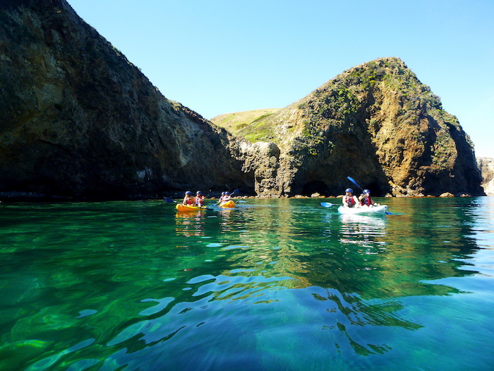
Enjoying the crystalline water and plethora of sea caves at Channel Islands National Park. Photo courtesy of Santa Barbara Adventure Company
Santa Barbara’s Channel Islands are a National Park surrounded by a Marine Sanctuary. Lying just 12 to 20 miles off the coast they feel like another world. Remote and wild despite the relative proximity to So-Cal’s huge population centers, they are one of the least visited National Parks in the country—largely because the only way to get there is via the Island Packers ferry service or paddling yourself. Once you get yourself to the islands, Santa Barbara Adventure Company runs kayak tours to a stretch of sea caves on Santa Cruz Island that rival Mendocino’s. If you have some reasonable Level 2-3 skills, you can also bring your own kayaks or SUPs on the ferry and spend the day exploring on your own. And if you have even more skills, more time and camping permits, you can spend a week or more crossing from island to island.


