Mar/070
Positively Path-ological

Photo: Eric C. Gould
Nor Cal Trail Runners Tell Us About Their Healthy Obsessions and Favorite Dirt
Trail running is an equal opportunity sport. It doesn’t require much money or skill, and everyone can break a personal record of some sort. That is, if you bother to be competitive at all, because you certainly don’t have to. You can run for purely therapeutic rewards.
With thousands of miles of open space in Northern California, it’s no wonder that runners of all shapes, sizes and abilities take to the trails daily for a dose of low-cost physical and mental therapy.
But how can you discover this region’s most fantastic trail runs without feeling like a member of the Lewis and Clark expedition? Well, you might start by following the footsteps of some of our readers on their favorite Nor Cal trails. Here they give you the details. Breaking a sweat is up to you.
Runner:Catra Corbett, Fremont
Bio: I am 42 years old. I have been running since 1996 and running ultramarathons since 1998. I have run over 200 ultras, 51 of them 100-milers. I hold the women’s speed record on the John Muir Trail, 212 miles from Yosemite Valley to Mt. Whitney in 5 days, 15 hours and 50 minutes. I also hold the overall yo-yo record on the Muir Trail, 424 miles in 12 days, 4 hours and 57 minutes. In 2002, I ran the Marathon Des Sables in Morocco, a six-day 151-mile race through the Sahara Desert. The runners have to carry a 20-pound pack with all your gear. I was the 19th woman overall and second American woman. Also in 2002, I completed a solo 100-mile run through Yosemite with a nine-pitch rock climb called Nutcracker at mile 57 with my then-husband and noted climber Ammon McNeely. For more info, visit my website: www.trailgirl.blogspot.com.
Average weekly mileage: 80-150
Favorite epic run:Ohlone Wilderness Trail, Alameda County. It starts from Mission Peak in Fremont and weaves for 28 miles through the Sunol Regional Wilderness to Del Valle Regional Park near Livermore. I run a solo 100-mile training run on it every May. I finish off my journey with an official race called the Ohlone 50k, from Mission Peak to Del Valle. In the Sierra, I love doing repeats up and down Half Dome starting from Curry Village in Yosemite Valley. Steep single-track granite trails with the most spectacular views.
Distance and elevation gain: From Mission Peak to Del Valle, it’s 28 miles one way with several long uphills. If you just do the Mission Peak portion, it’s a nice steep 2,700-foot climb to the top on a fire road; 6 miles round trip.
Terrain: This trail run is a combination of singletrack and doubletrack all in pine forest. There are some steep sections broken up by some cruiser flats.
What makes it great: It’s my backyard. I was born and raised in Fremont and when I started trail running that’s where I began. On a clear day, the views are awesome. It’s a tough run – it’s the trail that has made me strong. Mission Peak is one of the most beautiful little mountains in my eyes. It seems easy but it’s all uphill from the start.
Location and parking: Mission Peak Regional Preserve, Fremont. Trailhead is off Mission Boulevard. There are maps at the trailhead. Parking is free and plentiful.
Dogs Allowed: Yes.
Runner:Matt Keyes, Auburn
Bio: After training for a road marathon on the trails around Auburn and deciding the training was more enjoyable than the event, I’ve been hooked on running trails. (Editor’s Note: Last year, at age 32, Matt ran the infamous Western States 100 from Squaw Valley to Auburn in just over 25 hours, 9 minutes.)
Average weekly mileage: Varies from 20s when I’m coaching my two kids’ soccer teams to 75ish when training for a long run.
Favorite epic run: Any of the single-track trails around Auburn, but one of my favorite sections is from our home in downtown Auburn to the fire station in Cool on the Western States Trail.
Distance and elevation gain:About 7 miles one-way. Total elevation change is probably somewhere around 2000 feet.
Terrain:Most of the route is on single track. Typical of most of the stuff around here, the trail condition varies with the seasons from dusty to muddy and if you’re lucky right in between. There are long stretches of fairly level ground and the entire route is runnable. There are some great downhills, varying from screaming along and jumping rocks and water bars to a section of “Holy crap, I think I might be flying!” downhill.
What makes it great:Near perfect single track that descends into the American River canyon, crossing historic No Hands Bridge with views of the confluence of the north and middle forks of the river. This trail has the stuff: technical single track, views of the river, a waterfall, chances to get your feet muddy if it’s been raining. The downhill stretch coming from Cool toward the river is some of the best downhill running I’ve found. As many times as I’ve run it, I still feel like a kid flying down it. If you allow enough time, you can stop at the local downtown Auburn coffee shop, Depoe Bay Coffee Company (893 High St.), which roasts its own beans, and replace some of those calories with a nice hot or blended stimulant to suit the weather.
Location and parking: If starting from Auburn, the Overlook parking lot on Pacific Street is a good starting point. If starting in Cool, the fire station off Highway 49 is the place. Water is available along with porta-loos at either starting point.
Dogs: Dogs are allowed and not required to be on a leash on the trails.
Runners:Sarah Spelt & Wendell Doman, Walnut Creek
Bio: After several years of running road marathons, we discovered trail ultras about 15 years ago and have been running trails ever since. In addition to putting on more than 25 events annually with our family business, Pacific Coast Trail Runs (www.pctrailruns.com),each member of our family typically runs a few 100-milers every year, either as organized events or just as fun runs.
Average weekly mileage: Varies from 25 to 100-plus, depending on what we have going on.
Favorite epic run: Any section of the Diablo 50-Mile course, but one of our favorite sections is from Mitchell Canyon gate over Eagle Peak to the summit of Mt. Diablo.
Distance and elevation gain:About 7 miles one way, climbing from 586 feet to the summit, 3,849 feet.
Terrain: Mt. Diablo has a bit of everything, which is one reason we love running and training there. The section up over Eagle Peak, though, is very technical singletrack that passes Mitchell Rock and then runs along a ridgeline before you emerge on a fire road that takes you through Juniper Campground and within a mile of the summit. The last mile heads back on singletrack trail.
What makes it great:We love running on Mt. Diablo regardless of the trail we’re on, but the trail up over Eagle Peak and on to the summit combines all our favorite components in a short distance – technical exposed up-and-down singletrack over rocky ridges, spectacular views of surrounding towns from the ridgeline, a runnable downhill with a seasonal stream crossing, a good long climb up to the campground, and the reward of seeing San Francisco, Oakland, the Sierra, and more from the summit of this fabulous mountain. Run it at sunrise and it’s truly awe-inspiring.
Location and parking: Mitchell Canyon Gate is one of the entrances to Mount Diablo State Park, and is accessible through the town of Clayton. Parking is available for $3. Take Coulter Pine Trail to Mitchell Rock trail to get started on your run.
Dogs: Dogs are not allowed on the trails.
Runner: Scott Dunlap, Woodside
Bio: I’m a 37-year-old trail and ultra runner (see my blog at www.runtrails.blogspot.com), who also enjoys biking, hiking, and getting outside in general.
Average weekly mileage: 60
Favorite epic run: Purisima Creek Loop, located in the Purisima Creek Open Space Preserve, San Mateo County.
Distance and elevation gain: 12 miles, approx. 4,000 vertical feet
Terrain: Mostly shady singletrack and fire roads lined with views, redwoods, and ferns.
What makes it great: I’ve run hundreds of trails in California, and this offers all the best of Cali in one run. You start with epic ocean views and then run down the ridge into the redwood canopy. Entering the redwoods transforms the seascape into a lush canopy of ferns, moss, and trees where the oxygen is rich. I just can’t get enough of this run! This is where I take all my out of town guests, runners and hikers, alike.
Location and parking: The Purisima Creek Redwoods Open Space Preserve’s main entrance and the North Ridge Trail trailhead are located on Skyline Boulevard (Highway 35) 4.5 miles south of Highway 92. Take Harkin’s Ridge to Soda Gulch Trail, then down Purisima Creek Trail and then run back up Harkin’s Ridge.
Dogs: No.
Runner: George Lake, Truckee
Bio: 43 years old. Enjoy marathons. I also enjoy hiking, mountain biking, and snowboarding. Recently gave up working in network security to pursue adventure travel guiding and teaching math.
Average weekly mileage: 20-45
Favorite epic run: Truckee River Legacy Trail / Martis Valley / Dry Lake
Distance and elevation gain: From four to 25-plus miles, with minimal elevation change (adding the Dry Lake section will add a 700-foot climb)
Terrain: A little of everything: Mostly fire road and maintained trail along the Truckee River and Martis Creek with some pavement connecting sections, and some steepish singletrack and fire road on the Dry Lake option.
Location and parking: The Legacy Trail starts from the Truckee Regional Park (plenty of free parking). There are plans to extend this trail but it currently ends after a couple of miles, at which point you can turn right and run along a bit of road to Martis Creek Lake. From there, continue east and across Highway 267 for a nice loop through Martis Creek Wildlife Viewing Area. And/or cross the dam and head up the hill to Dry Lake then follow the fire road back down to Martis Valley.
What makes it great: Great views and the convenience of being able to leave from town without having to drive. And the flexibility is great: Knock out a few easy miles on the Legacy Trail or get in 25-plus with a nice hill climb.
Dogs: Dogs are mandatory, almost (this is Truckee). No leashes are required on any of the individual trails but bring a leash for road crossings if hooking up the trails for a longer run.
Runner: Mike Erbe, Santa Cruz
Bio: I am a 51-year-old wanna-be triathlete and although I’ve been running for years, it is only in the last six or seven that I have run trails. My favorite running races include the Mt. Madonna Challenge, the Wharf to Wharf, and the Firecracker 10K, all of which are in the Santa Cruz area.
Average weekly mileage: 20
Favorite epic run: UC Santa Cruz/Pogonip Preserve trails in Santa Cruz
Distance and elevation gain: 6-10 miles with 300-1,000-plus feet of climbing
Terrain: From the starting point in Harvey West Park in Santa Cruz, the run up through Pogonip to the university is amazing. It is mostly singletrack and quite hilly with trails that wind though woods and meadows. Numerous trail options are available depending upon your time and energy.
What makes it great: This is a great run because of the constant variation in scenery, terrain, and trail options. Pogonip Preserve, coupled with the adjacent university land, features a vast network of running trails. Singletrack abounds (as do the hills) and there are also some sections of fire road. The sandy soil drains well so the footing is great even when it’s been raining. And the university has a rubber track overlooking Monterey Bay if you’re inclined to toss in some mid-run speed work.
Location and parking: A great place to start is from the bottom of Harvey West Park, a city park. From Highway 1, turn onto Highway 9 toward Boulder Creek. Turn left on Fern Street, and left on Limekiln. Eventually, Limekiln turns to Evergreen and leads to the park. There is plenty of free parking and a place to change/shower (or swim if you are a tri-person) after the run.
Dogs: Dogs are allowed on only a few of the trails within Pogonip Preserve.
Runner: Terri Schneider, Aptos
Bio: Speaker, writer, coach. Show me a trail and I’ll run it! (www.terrischneider.net)
Average weekly mileage: 20-100
Favorite epic run: I’ve run trails all over the world and always come back to my local favorite (it’s kind of home base), Big Slide/West Ridge loop in Nisene Marks State Park, Aptos.
Distance and elevation gain: About 19 miles, lots of up, lots of down
Terrain: If you get creative on the front end you can do this run on about 85 percent single track. That is my preference. The single track ups and downs are steep and challenging but the trail is usually well-maintained, barring any slides or treefall. The intermittent fire road sections are a nice place to cruise easy.
What makes it great: I’m totally psyched that given the numbers of runners in Nisene Marks Park each week, hardly anyone else runs single track. Woohoo! That means most of the time I have miles and miles of trails to myself. I’m all about going solo or with one or two training partners. Trail running to me is a Zen experience.
There are certain sections of single track in Nisene Marks that have unparalleled views of the ocean and other areas of the park. The trails are quiet, smooth, challenging and you are completely ensconced in redwood forest. The perfect backdrop for a Zen experience. When my mom asks me if I’m going to church on Sunday, I tell her “Yes! I’m going running in Nisene Marks.”
Location and parking: Enter Nisene Marks via Soquel Drive in Aptos. You can park at the entrance to the park if you want to do the whole run, or you can drive in to the parking lots along Aptos Creek Road to shorten the run. If you enter the park via the kiosk, there is a fee of $6. Or you can buy an annual California State Parks pass for $125.
Dogs: Dogs are allowed on leash up to the second steel gate in the park (about 3 miles in).
Runner: Francesca Stone, South Lake Tahoe
Bio: I’m a Special Events Coordinator for Barton, the local hospital, exercise addict, trail runner and dog/animal lover.
Average weekly mileage: 30+
Favorite epic run: Eagle Point to D.L. Bliss State Park via the Rubicon Trail
Distance and elevation gain: The Rubicon can be run in one direction (6.3 miles), or as an out and back (12.6 miles). If you decide to do it in only one direction, you must leave a second car at one end, or leave a bike and ride back to your car via the road (mountain bikes are NOT allowed on this trail).
Terrain: Dirt singletrack, lakeshore views, man-made features
What makes it great: A classic Tahoe trail run should have stunning mountain vistas, lake access, dog-friendliness and, of course, a great altitude pump. One of my favorites that meets the above criteria is Eagle Point to Bliss State Park on the Rubicon Trail. And yes, there are often eagles at Eagle Point so look up from the trail once in a while.
There are so many great spots to stop along the way that it’s easy to get distracted. I like to run the trail out and back, then have lunch at the car. I can then hike it round trip again, taking some time to explore the Vikingsholm Castle, soak up the sun on the beaches or boulder some of the great problems around Rubicon and Bliss.
Location and Parking: Eagle Point Campground is 8 miles from South Lake Tahoe on Highway 89 north. A State Park Pass or day pass is required to drive into Eagle Point or Bliss State Park Campgrounds. Free parking is available along the highway but this will add some mileage to your day.
Once inside Eagle Point Campground, drive about a quarter mile to the Lower Eagle Point Campground parking area. From here, the single-track trail slopes gently to the lakeshore then skirts Emerald Bay, eventually leading to a gradual climb with unobstructed views of Tahoe’s South Shore and towering Freel Peak. The trail rolls on for several more miles rounding Rubicon Point and the historic lighthouse before terminating in the Calawee Cove parking area of Bliss State Park. For more information on D.L. Bliss/Emerald Bay State Parks, check online at www.parks.ca.gov.
Dogs allowed: Yes, it’s a dog-friendly park.
Mar/071
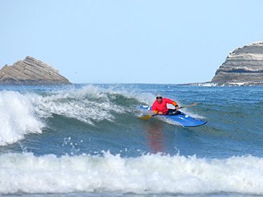
Dave Johnston carving in the finals at the Portugal

Profile: Big Wave Dave
Photo: Foto-Reportagem
World Cup.
21st Annual
Santa Cruz Kayak Surf Festival
March 16-18, Steamer Lane
World Champ Looks to Add to His Portugal Victory on Home Surf
Name: Dave Johnston
Age: 44
Home surf: Santa Cruz
Occupation: Kayak instructor, outfitter and Sherpa
Career Highlights:
- 2006 World Cup Champion, Portugal
- 1999 World Champion, Brazil
- 2006 US National Champion, Cape Hatteras
- 2002 US National Champion, Outer Banks
- 8-time US Team member
- Winner of the Grand Prize in 2005 Best Wave Video Contest
Favorite moves: Cartwheel in the tube (aka “karate chop”), a roundhouse 360 off the lip.
Most memorable ride: One of my most memorable rides was at Davenport Landing on a very big day. I managed to catch a wave from way outside at the north point, surf it across the channel in front of the beach and link it with a wave coming the other direction from the south reef. That was one hell of a ride!
Biggest wave ridden: I have ridden several waves in the 15-20 foot range at Davenport and Middle Peak at Steamer Lane in Santa Cruz. But when I’m on the wave I don’t have time to think about how big they are, only about how to pull it off without any problems.
Scariest moment: Riding storm surf at the Lane, a big section pitched over onto me and just obliterated me, removing the paddle from my grasp. After hand-rolling upright, another huge wall of water and then another drove me closer and closer to the cliffs. While sitting in my kayak about 20 feet from a death trap of car-size boulders with person-size gaps between them, I realized that the next big set wave was about to deliver me into an ugly reality.
Rather than bail on my boat and swim the half mile to the beach, I started backpaddling furiously with my hands. The wave swept me up and perched me on top of the rip-rap pile where I quickly exited without injury. This was probably the luckiest I’ve ever been. Not as brutal as swimming in class V though.
Future of kayak surfing: High performance carbon-kevlar surf-specific boats are incredibly fun surfing machines. The more whitewater boaters try them the more they’ll be heading out to surf in the ocean. That’s great as long as they practice good surfing etiquette toward other surfers already there. Or better yet, surf away from crowds in places that you have to paddle a little ways to get to. Find the perfect wave and ride it all by yourself.
Who else to watch in Santa Cruz: Rusty Sage rips; he’s last year’s champ. Also Jono Stevens, Demany Smith, Jeff Burlingham, Ken King, Dick Wold, Sean Morely, and Vince Shay are all ones to watch.
Secret weapons: Having local knowledge and my new boat the Murkey Waters Twist with the quad-strap system.
Favorite surf spot outside CA: Easkey, Northern Ireland
For more information on the Santa Cruz Kayak Surf Festival, visit www.asudoit.com.
The competition starts Friday, March 16, at 7 a.m.
Mar/070
Move Your Body for Somebody

Add Meaning to Your Exertion – Sign Up for a Charity Event
By Maria Vitulli
Photo: The Leukemia & Lymphoma Society
Maybe you’re looking for a way to step up your training goals. Maybe you want to do something tangible for a cause that has struck a chord in you. Maybe you want to train with a new group of people or try a totally new activity.
Whatever the reason, participating in an event for a cause greater than your own performance can be a remarkably powerful and satisfying experience. Even traditionally singular sports such as running and cycling can take on a whole new tenor when everyone has a bigger goal in mind.
By virtue of the temperate climate and the philanthropic temperament of its residents, Northern California has a huge array of fundraising sports events for all kinds of worthy causes. You can choose from a fun 10-mile bike ride, to a challenging triathlon, to a weeklong mountaineering adventure.
Below are some highlights of the diverse events and organizations that allow you to help others through the simple act of moving your body.
Tour De Cure
Tour De Cure is actually over 80 separate cycling events that take place across the U.S. to benefit the American Diabetes Association’s mission to prevent and cure diabetes and to improve the lives of all people affected by diabetes.The organizers take pains to point out “it’s a ride, not a race,” with course options that can accommodate everyone from a weekend rider to a hardcore century veteran. You can ride by yourself or with a friend, or form your own team with five or more riders. Every rider pays a nominal registration fee and sets a fundraising goal, alone or with a team. In Northern California, there are Tour de Cure events in Sacramento, Silicon Valley and Napa Valley.
The picturesque Napa Valley ride is actually the largest event in the country with more than 2100 participants raising over $1 million last year. “Most people who participate have someone with diabetes inspiring their ride,” notes director Tom Hall, of the riders who range in age from “kids to the elderly.” The staging site of the ride is in Yountville with rides of 10, 25, 50 and 100 miles, to easily accommodate riders of all skill levels. This year’s event is on May 6 and will also feature live music, a silent auction, and fittingly, wine tasting.
Team In Training
Team In Training is a fundraising program for the Leukemia & Lymphoma Society to raise money and awareness for people with blood cancers. They have a truly unique, smorgasbord approach of not staging one specific event, but training and sending teams to more than 60 established endurance sports events all over the world, including many in California. You can choose to run or walk a whole or half-marathon, do a triathlon, ride in a century or even complete a cross-country ski race anywhere from Hawaii to Rome to Alaska.
Here’s how it works: You sign up for a “season” with Team In Training, typically 3 to 5 months prior to the event you want to compete in, and they then set you up with a regional team, training schedule, and a certified coach. When your event approaches, your airfare, accommodations, support and entry fees are paid for. All you have to do is raise funds for the Leukemia & Lymphoma Society (the fundraising commitment varies depending on the event), train, and show up. It’s an ideal set up if you always wanted to do an event in an exotic location, but felt overwhelmed by the training and logistics of it. Plus, you get the added benefit of camaraderie from a being on a team you’ve trained with for months, and knowing that you’ve raised funds and awareness for a worthy cause.
There are extremely active Team In Training chapters in the San Francisco and Monterey Bay areas. “There are a lot of participants in the Bay Area,” says Team In Training’s Barb McDowell. “We live in a very philanthropic area, and we’re lucky the weather allows us to train all year round.”
Climbing For Kids
Climbing for Kids is a program of Bay Area Wilderness Training (BAWT), under the Earth Island Institute, to introduce at-risk youth from urban areas to the outdoors and the impact a relationship with the wilderness can make on their lives. Using a unique “multiplier-model” approach, BAWT teaches adult leaders of existing youth groups skills in backpacking, camping and team-building. It then gives them access to a huge “gear library,” everything from sleeping bags to stoves to hats, which can outfit up to 150 people at a time.
Instead of a one-time trip, this innovative approach enables leaders who already have a relationship with the kids to go out into nature with them again and again. “The people who train with us are really interested in instilling a love of wilderness and environmental ethic in youth,” says Cliff Agocs, coordinator of Climbing for Kids.
Climbing for Kids raises funds to support BAWT through six separate fundraising climbs on Mount Rainier, Mount Shasta, and Mount Whitney. Participants in these climbs agree to meet various fundraising goals, depending on the mountain, and are then supplied with more than $1500 worth of free gear and food, and a certified professional guide. Organized hikes to help prepare for the climb are offered and technical training with ice axes and crampons takes place on the mountain before and during the climb. “Many of the climbers are at the beginner to intermediate level,” says Agocs. “It’s a great way for someone to promote what they love.”
The Coolest 24
Participating in a local, homegrown event for a cause can be a great way to help your town or athletic community give to a cause. Such is the case with the second annual Coolest 24 Hour Mountain Bike Challenge in Cool, in the Sierra foothills south of Auburn, the so-called “Endurance Capital of the World.” When organizer Jim Northey lost two friends to cancer within two weeks of each other, he decided to put his experience putting on mountain biking events to use to benefit the UC Davis Cancer Center. “Ninety-nine percent of us have been touched by cancer in some way,” he notes.
The Coolest 24 is the only 100 percent non-profit mountain bike race in North America, with some of the lowest race entry fees on the West Coast. Teams and solo riders race the 9.1-mile course loop for a full 24 hours. Northey makes it a festive atmosphere with a camp city, stuff hanging from the trees, and bands playing. He also notes with a chuckle that he has “a friend in a Sasquatch outfit roaming around the woods of the course. The sense of humor is extended to the awards, with a Liberace-worthy trophy and special “sandbagger awards” (a dumpster full of garbage), for pros who enter as amateurs.
The good mojo is contagious, Northey says. “Most of the winners gave the prize money back to the cause last year.”
Climb Against the Odds
For 12 years, the Breast Cancer Fund has enhanced its mission of identifying and eliminating environmental causes of breast cancer by literally summiting a mountain. Last year’s team of 40 dedicated climbers, comprised of breast cancer survivors, family members and friends, climbed Mount Shasta and raised over half a million dollars for the cause. But as climb coordinator Connie George observes, “It’s not about the summit.”
Described as a “bonding experience” where climbers are literally roped together, Climb Against the Odds’ participants do not need to be experienced climbers. However, they are asked to commit to a six-month training schedule that includes one hike a month with a regional training team and a mountaineering class. They also receive $1500 worth of top-of-the-line gear. “Last year, we had people on the team from age 18 to 68,” George notes.
In addition to a fee to cover the costs of their climb, each climber is required to fundraise, with most going well over the minimum. As added incentive, participants who meet their fundraising goal by April get half of their climbing fee waived. This year’s climb will again be on Mount Shasta in July, and since there are a limited number of spots, sign up is done by application.
AIDS/LifeCycle
Now in its sixth year, the AIDS/LifeCycle is a seven-day 545-mile bike ride from San Francisco to Los Angeles in June, with proceeds going to the San Francisco AIDS Foundation and the L.A. Gay & Lesbian Center. Virtually a traveling city, more than 2,200 participants raised over $8 million for HIV/AIDS-related services last year, more than any other event in the country.
In exchange for their fundraising, cyclists receive ride support from hundreds of volunteer “roadies” who set up tents, feed and hydrate them, and provide bike repair and first aid. Though the physical challenge is significant, the AIDS/Lifecycle community encourages anyone with the will to participate—like the group of cyclists living with HIV, known as the “Positive Pedalers.” The ride is a truly unique way to experience the California coastline with an incredibly dedicated and committed group of people.
It’s Not (Just) About You
The above events are just the tip of the iceberg when it comes to sports events for causes. If you are lucky enough to be healthy and able to participate in a sport, think about doing it for someone who might not be as fortunate — and don’t let a fundraising requirement intimidate you. Almost all events that require fundraising have a ton of support and training to help you raise money, everything from workshops to personal web pages to mentors to give advice. It is easier to raise funds for a cause than most people think, and if the thought of asking for money makes you uncomfortable, keep in mind: It’s not about you. You’re asking, and moving, to help someone else.
Mar/070
A Wimp’s Guide to Adventure Travel

Peruvian Cross Country Champion Ruso Covarubias is used to vertiginous Andean singletrack.
By Christa Fraser
Photo: Steve Ripley
Peak-bagging Kilimanjaro. Rafting the Futaleufu. Mountain biking Whistler. Heli-skiing Alaska …
I have my dream list of adventure travel trips although each intimidates me for one reason or another. For one, I am built like a Corgi, lots of torso and not much in the way of leg length—a fact which usually guarantees me a place at the back of the pack. Two, I am perpetually broke and these are not cheap endeavors. Three, I am perpetually broke. And finally, I’m a wimp.
To be clear, I have been called every variation of the word wimp at some point or another. I’m not proud of this but I have made peace with this and other shortcomings and learned to live with them. Learning to travel with them is another matter entirely.
Recently, I took a last-minute mountain biking trip to Peru. It wasn’t on my official to-do list yet but this trip had some qualities that would make it a perfect place to hone my future as an adventure traveler. First off, it has really high mountains—the second loftiest in the world after the Himalaya. Clearly, I would have plenty of chances to confront my desperate fear of heights and technical descents. Secondly, I would be going with perfect strangers. Finally, everyone else would be way better at biking (and geography, but we’ll get to that later) than me. This would give me a chance to perfect my bringing-up-the-rear/holding-back-the-entire-group skills.
In short, this trip would allow me to hone my adventure travel philosophy so I could start marking off my adrenaline-fueled, scare-the-crap-out-of-myself tick list. Here are a few of my hard-earned lessons:
Lesson #1: Never Panic.
And if you do, make sure there are no witnesses.
After a 14-hour flight to a foreign destination, it’s nice to find the people you’re supposed to meet, be driven to your hotel and sleep away the exhaustion. It’s not so nice to be stranded in an airport 6,000 miles from home, unable to find your host.
I was to meet up with Mike “Enrico Suave” Brcic, the owner of Fernie Fat Tire Mountain Biking Adventures in British Columbia, and Eduardo “Wayo” Stein, who owns Inka Adventures Mountain Biking Tours in Lima, Peru. When my flight arrived shortly before midnight, I couldn’t find either of them. Granted, I had zero idea what they looked like and no way to contact them.
A knot of fear formed in my throat. I was a female foreigner alone in the Lima International Airport with an enormous plastic bike case, two heavy bags and a pitiful traveling budget. It was approaching three in the morning. Taxi drivers and shady characters were offering to take me anywhere I wanted, or so they said. I was exhausted, overwhelmed and intimidated by the dense circle of men yelling and waving signs at me. I was hopeful that Mike and Wayo would arrive any minute.
They didn’t.
After a while, dark thoughts percolated into my reasoning: I am stuck by myself in Peru and my return flight isn’t for 10 days. I am going to travel alone. I am going to get mugged/robbed/sick. I will never make it home again.
I called my fiancé, in tears and utterly panicked.
“Did you get there ok? How was your flight?”
“I am stuck in the airport—by myself.”
“What? Have you talked to them?
“No.”
“You can’t reach their cell phones?”
“No. I don’t have their numbers.”
“You left the country … to meet two guys you’ve never seen before … in an airport in the middle of the night … and you didn’t bring their cell numbers?”
At 3:30 a.m., Mike finally arrived and I figured out why we hadn’t been able to meet up. Wayo had arrived on time to pick me up but I had waited in customs for Mike to arrive; only Mike’s flight was delayed several hours. Wayo couldn’t go through customs to find me, so he left when I never came out of the gate.
“Were you OK waiting alone?” Mike asked.
“Oh yeah, I was fine. I knew it would all work out.”
Lesson #2: Take care of your basic needs
In other words, sleep/eat/heed the call wherever and whenever you can.
Most adventure travel trips are pretty cush and this one was no different. Other than sleeping in the airport that first night, we were well taken care of. Wayo selected picturesque yet cheap hotels and excellent restaurants for us. A support van with helpful drivers followed us when possible or met up with us at key spots. Peruvian energy bars and fresh drinking water were offered to us throughout the day, as well as the opportunity to wimp out and hitch a ride or nap for the rest of the day’s miles.
Nonetheless, we were riding our mountain bikes on vertiginous livestock trails and vestigial Inca trails in the high Andes through remote Quechua-speaking villages. There were no port-a-potties and in many cases there weren’t any bushes. I have a bladder better suited to a squirrel and I was the only woman riding.
I’ll admit it—I answered my bladder’s call wherever necessary, including just off the pathways to a few Inca ruins, which could be one of the reasons I came home with a bad case of Atahualpa’s Revenge.
Or it could be because I welcomed cultural opportunities that forced me to forego the essential rules of eating while traveling abroad. Every guidebook says to try the local specialties (even if roasted guinea pig or alpaca isn’t your ideal protein source), making sure to avoid unbottled water and ice, to peel any fruit or potatoes yourself, and to be certain that any animal flesh is well cooked.
But what do you do if the locals offer you homegrown potatoes right from their field, fresh cheese and a swig of rotgut (popular Peruvian varieties are made from fermented corn or spit and known as Chicha or fermented sugar cane known as cañaso)? In the spirit of cultural sharing, I felt compelled to at least take a bite and a sip even though I was certain that drinking fermented spit was going beyond courteous behavior. (That’s what all those pre-trip shots were for, weren’t they?) I knew I would never again stand in that same field in Peru with that farmer and his family. I didn’t want to turn down an opportunity for a cross-cultural bond. But when my stomach turned on me the next day, I remembered that I didn’t peel those potatoes.
Lesson #3: Check your ego at the airport
After all, you’re not there to whine or win.
In a video clip from our trip, there is a scene that makes me laugh. A camera mounted on the steer tube of journalist Steve Ripley’s bike captures an epic ride along the steep banks of the Urubamba River. Eventually, Steve stops to rest with most of the group. The camera turns back to the trail and for an interminable time nothing happens. They were waiting for me for so long that the tape ran out before I arrived. The narrow singletrack with a certain-death cliff face on one side had me pedaling at glacial speed. Yet, when I finally wheeled up, they assured me they had only waited a couple of minutes.
Living with a group for several days or weeks requires diplomacy. I did my part by never complaining even though the riding was somewhat beyond my skill, fitness and fear thresholds. They did theirs by never pointing out the obvious to me and by noting that the extra time was useful for taking photographs.
Instead of feeling ashamed, I quickly learned that there are certain advantages to being the slowest of any trip. For starters, you usually have no witnesses to moments of lameness such as random exclamations of abject fear or pain. No one has to see you anxiously walk your bike past a bull after you’ve bragged to them about growing up on a farm and how tough it made you. No one will witness you walk the corners you can’t pull (in my defense, not making them could have meant falling off the edge of the world!), nor will they see you eat trail repeatedly.
And instead of feeling like you have to prove something by making excuses for why you aren’t as fast or as skilled, let your co-travelers help you when appropriate. I had to be pushed up a hill to the village of Rosaspata at 12,000 feet while in the grip of altitude sickness. Ruso “Turbo Ruso” Covarubias, the four-time national cross-country champion of Peru who grew up in that area, did the honors easily. And you know what, I welcomed the help. Let’s face it, sometimes your choice is between eating a fat slice of humble pie or holding up the entire group while you try to prove something. I’ll take the pie and the high fives at the top, thank you.
Lesson # 4: Don’t forget that you are representing your native country
But if you do forget, everyone else will remind you.
Estonia is somewhere near Finland, Poland is somewhere near Russia and Yugoslavia. Canada is north of the US and Peru is south. Overall, I feel pretty good about my geography skills—when I’m in the United States. Time and again, I was shown up as the epitome of the ignorant American, particularly in regards to geography and world politics.
The two Canadians, Mike and Steve, embarrassingly knew more about US policy and geography than I did. At some point, it became a funny albeit painful joke to ask me about geography or politics. The less I knew, the funnier it became. When Canadians can name the leader of each province and know details about the political history of each but I can only name Gov. Arnold Schwarzenegger, there is clearly a problem. But I countered my ignorance with a lot of curiosity.
Acting like you know everything when you clearly don’t is a certain recipe for adding “ugly” and “overbearing” to the stereotypes that Americans are often pegged with abroad. So if you’re headed down that road, stop and take out a guide to good traveling behavior. You may be the only American some people meet. In several villages, it was apparent that my citizenship, if not my skin and hair color, was a novelty. Leave them with something good to say. But don’t worry—someone will still make fun of you.
Lesson 5: Leave something good behind
And not just your Soles.
It’s easy to be separated from your money while traveling. You have to be vigilant that you are getting back proper change in an interaction, that you are being charged fairly and that the money you receive is real. In Peru, I lost count of the times that I got a fake five Soles piece as change (Peru’s national currency is the “Nuevo Sol”). Yet I couldn’t use the fake Soles anywhere because Peruvians are alert to this scam, so I’d be out about $1.50 U.S. each time.
Peru is a cash-poor country by US standards, with a per capita income at less than $6,000 per year. This means that the average full-suspension mountain bike is worth a good chunk of a year’s income. Throw in a pair of nice Italian cycling shoes, a Camelbak, a helmet, etc., and you’re riding half a year’s worth of Peruvian income. Still want to haggle over that alpaca scarf?
Admittedly, travelers bring in a lot of money to local economies. In turn, locals add authenticity to a traveler’s vacation. But we wanted to benefit the villages we passed through in a more direct way.
Mike passed out notebooks and pencils to the children in several small villages. Maybe it wasn’t a good idea because in the future all foreigners may be expected to bring gifts, but interacting with dozens of excited kids at a time was the best part of the trip. It felt good to give them something practical. And I am sure that teaching them how to high-five and say, “Trick-or-treat, smell my feet,” will have a lasting impact on the community, for better or for worse.
Adventure travel is pricey (although a good lesson in the relativity of being broke) and it can be scary to push your physical limits so far from home. But I can think of no better way to get to know the rest of the world and our place in it. At the least, it helps with geography. In my case, I learned that diplomacy counts more than pride or physical prowess, money isn’t the only currency and you stop being a wimp the minute you try something that makes you nervous.
Kilimanjaro, here I come—anyone care to give me a push?


