

- California Enduro Series Announces 2024 Schedule - 11/19/2023
- ASHLAND MOUNTAIN CHALLENGE 2023 – CES RACE REPORT - 10/04/2023
- China Peak Enduro 2023 – CES Race Report - 09/04/2023
A Point Reyes sea kayaking adventure
Words and photos by Chuck Graham
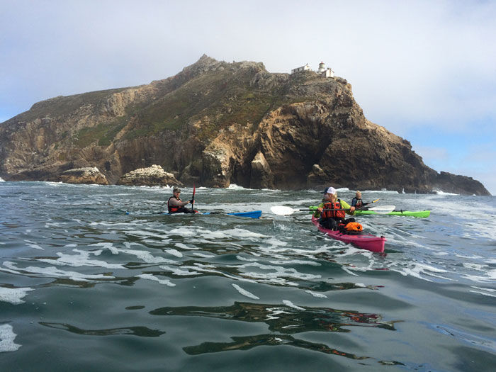
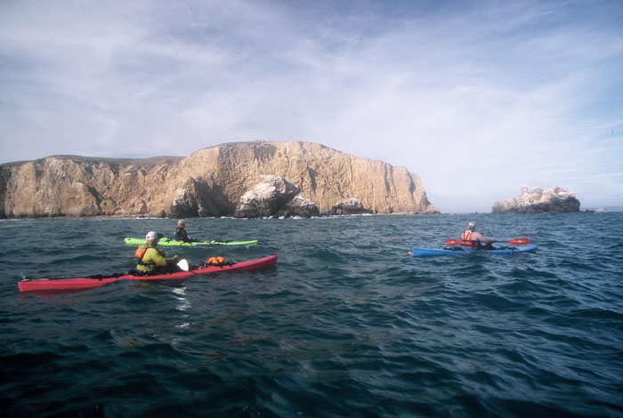
Taking a break beneath the Point Reyes Lighthouse.
The incessant roar from Jack’s Beach never waned throughout the night. The wind was howling across Bodega Bay, leaving an uneasy feeling amongst four hopeful kayakers aiming to paddle south around Point Reyes Lighthouse and into Drake’s Bay.
Starting Out
The ragged coastline of the triangular-shaped Point Reyes National Seashore is swept in unpredictable currents, unruly surf and towering cliffs. Point Reyes is considered to be the second foggiest place on the planet and winds have been clocked at 133 mph at the lighthouse. It’s these obstacles that can make for a challenging kayaking trip.
“Tomaltuous Bay”
I thought mid-week there would be no kayakers on the water, but there were quite a few along the west side of the bay with many of its beaches occupied for the night.
Myself and three other kayak guides from the Channel Islands National Park – Brad Greenbaum, Matt May and Ryland Grivetti – put in next to the decaying single hull boat behind the Inverness Market, and instantly we paddled into a northwest headwind. We paddled nine miles passing Hog Island, pushing toward sunset when we settled on Jack’s Beach. There was only a sliver of sand as the approaching high tide surged onshore. We neatly stacked our kayaks and tied them together before hauling our gear behind a dense thicket of coastal sage scrub.
A narrow path led inside a seemingly impenetrable thicket of coyote bush and poison oak before opening up beneath a giant grove of Cypress trees. It was anything but silent – our continuous friendly banter was challenged by the rush of surf washing through from Tomales Bluff to Tom’s Point.
That night around a crackling fire, we agreed that if the surf was too big at dawn to exit Tomales Bay, then we would regroup and camp as close as we could to the open ocean. Just after sunrise we effortlessly paddled with an outgoing tide and rode it until the surf dictated otherwise. Six-to-eight foot hammering waves battered the peninsula and outside the waves were ten-to-fifteen feet.
Instead, we landed our kayaks at Alvalis Beach and scrambled along the wave-battered coast out to Duck Beach for a good look at the surf. It was cranking and I sensed some anxiety amongst the boys.
“We’re going to have to consider going back to where we launched,” said May. “There’s no way out of this bay,” Grivetti added.
As we studied the sea conditions we did receive some comic relief watching in amazement as two fishermen in a 22-foot Radon gunned into Bodega Bay, riding on top of a wave. The captain looked supremely confident at the helm. One hand was on the steering wheel while gazing back over the stern, a cigarette dangling from his mouth and an 8am Budweiser in his other hand, clearly a man on a mission who would not be deterred.
Our rest day allowed us to scout around for an exit plan. We agreed to camp at North Blue Gum Beach, pitch our tents and spend the day hiking the spine of Tomales Point Trail and the Tule Elk Preserve. We followed a path from the beach to the trail and suddenly everyone breathed a sigh of relief. We had an excellent vantage point to view the outgoing tide and saw that the surf had dropped significantly. The surf was still booming on the west side of the narrow peninsula south of Bird Rock, but the waves inside Tomales Bay were on the wane.
By late afternoon we descended back down to our poison oak-choked campsite looking to get an early start for the lighthouse at dawn. The surf continued to subside through the moonlit night, and it was still dark when we loaded our kayaks and paddled for the open ocean early the next morning.
What a difference a day made. We were able to hug Tomales Bluff and paddle out of Tomales Bay with dry hair!
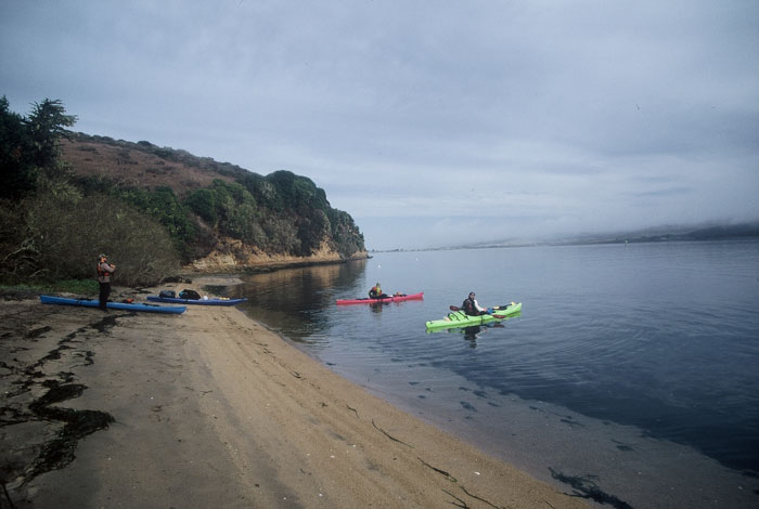
Leaving Jack’s Beach inside Tomales Bay.
Following Formations
From where we camped at North Blue Gum Beach to the Point Reyes Lighthouse was a 23-mile paddle, but we didn’t anticipate a five-to-ten knot southeast headwind or a stingy up-coast current.
We’d heard a lot of chatter about great whites in the mouth of Tomales Bay, Bodega Bay and the long stretch to the lighthouse. We didn’t take it lightly, so we stayed in formation for most of the day. When we needed a break for food or gear adjustments we came together, rafting up in the “duck formation”, as in sitting ducks. While we paddled we remained just a paddle’s reach from each other in a diamond formation. This was also relevant when visibility deteriorated to within fifty feet as we lost sight of the lighthouse from time to time in dense fog.
Point Reyes appeared ominous against an uncertain horizon. We had a steady ten knot southeast headwind and billowing fog was scaling the sheer cliffs leading to the lighthouse. For a time it felt like we were on a paddling treadmill and visibility fluctuated between okay and poor.
There were distractions to keep us on our toes throughout the paddle. In addition to sea otters and seals, a pair of humpback whales fed nearby amongst flotillas of common murres and red phalaropes. At one point we had seven mola molas swim around our kayaks. A couple of the bony fish even bumped the hulls of our formation.
The pesky up-coast current and southeast winds didn’t ease up while rounding the lighthouse. Swell washing up the cliffs rolled back out to us, creating some uneven paddling conditions down to Chimney Rock and finally oval-shaped Drakes Bay.
Drake’s Haven
To the Spanish, Sir Francis Drake was a ruthless pirate defeating and raiding their mighty fleet throughout New Spain in the 1570s. To the English, Drake was a maverick and a hero while circumnavigating the globe, but with the Spanish breathing down his neck Drake and his crew took refuge inside what was then Coast Miwok land and what is now known as Drakes Bay.
We finally experienced a tailwind and although we had to wait until the last five miles of our trip, it felt good paddling into the expanse of Drakes Bay and not having to worry about wind, swell and currents. It was just a matter of locating the correct marine terrace and the gritty mouth of Drakes Estero.
It looked easy enough on the map, but the mouth of Drakes Estero was hidden from view, and with no defined lineup or channel it was tricky getting inside the mouth. Grivetti paddled in first and skillfully surfed several waves past a flock of American white pelicans roosting at the end of the sand spit. The rest of us got in without a hitch as the estuary’s shallow waters rippled in the southeast winds.
We continued past a crude monument devoted to the seafaring exploits of Drake, and paddled with ease to the backend of the estero. It started raining, heavy at times. Mule deer gazed at us bewildered from the shoreline and a northern harrier swooped overhead. We paddled past the now defunct Drakes Oyster Farm and finished our trip at the road that leads to the lighthouse.
The winds were gusting to forty knots and even more so at the lighthouse where it was consistently fifty knots. The rangers shut visitation down and we could see a procession of cars heading our way. Brad was out in front as we paddled the narrow channels of pickleweed. Nearly at the road, Brad began hitchhiking from his kayak and flagged down the first vehicle that approached us. It was a Mercedes and the couple was more than willing to take Brad to our trucks on the other side of Tomales Bay. The rest of us dodged the chilly wind and rain by paddling into the circular culvert underneath the road. A few moments later a ranger peeked under the road and into the culvert.
“I’m the ranger and I saw a kayak off the road here,” he said. “Just wanted to know where you’re coming from?”
“We started in Tomales Bay,” I said. “We’re just finishing up, waiting for a ride.”
“What?,” he replied. “Well that was pretty f!#%*n’ ballsy. I’ve, never heard of anyone doing that before.”
Neither had we.
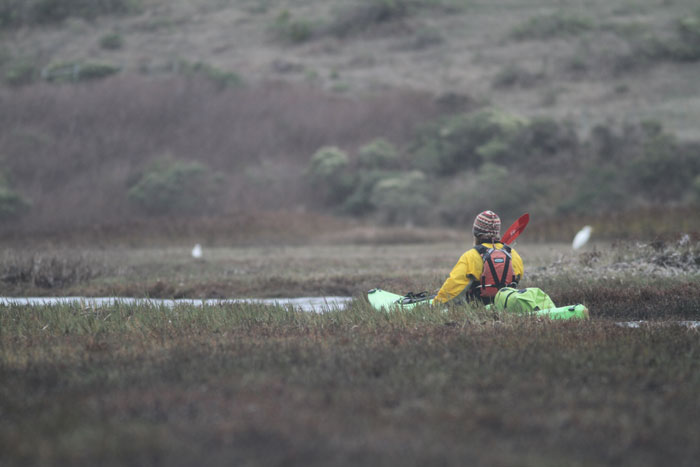
Exploring Drakes Estero.
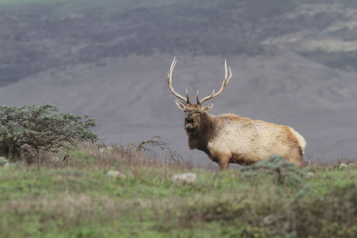
Tule elk bull bugling.
Paddling into Drakes Bay.


