By Pete Gauvin

Now is one of the best times to visit the Eastern Sierra for a dose of alpine solitude and adventure. The twilight of summer and the onset of fall is arguably the most peaceful time of year in this bold landscape tucked away from California’s swarming population centers by a little range of hills called the Sierra Nevada.
The summer crowds have begun to retreat to the suburbs of SoCal. The trans-Sierra passes have yet to be closed by snow, making the drive hours shorter for central and northern California residents via Tioga Pass through Yosemite or Sonora Pass to the north. The furnace-like heat of the Great Basin has been turned down to pleasant to encourage vigorous mid-day activity. And the aspen-lined canyons are choked with autumn color as an invitation to the high country. 
There’s no shortage of accessible lands for active individuals to stoke their fires. Approximately 98 percent of the land in Mono County is public. Among these lands are Inyo National Forest, Mono Basin National Scenic Area, Devils Postpile National Monument, and the John Muir and Ansel Adams Wilderness areas.
Bring your mountain bikes, backpacks, climbing gear, kayaks, or just a pair of trail shoes, and you’ll find outdoor nirvana in this expansive, stunning playground of alpine splendor and high-desert lonesomeness. You’re certain to find energy in the landscape.
Here’s a sampling of ways to spend it, utilizing the Mammoth/June Lake area as basecamp:
Hiking/Backpacking
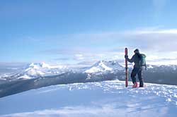
San Joaquin Ridge is an easy but spectacular warm-up hike beginning just above the town of Mammoth Lakes. This 4.8-mile round-trip hike begins at the 9,265-foot Minaret Vista, which offers superb views of the 13,000-foot spires of the Minarets, Mount Ritter and Banner Peak. The views only get better as you hike along the ridge toward Deadman Pass. You’ll walk on the Sierra Nevada Divide separating the east and west watersheds, while 11,053-foot Mammoth Mountain dominates the skyline at your back. A couple moderate climbs bring you to a 10,255-foot knob, where you a can survey a 360-degree panorama from the Yosemite high country to the White Mountains down south.
For a longer dayhike, an overnight backpacking trip, or the beginning to a longer high-country adventure consider the trail to Shadow and Ediza lakes, which lie at the base of Ritter, Banner and the Minarets. Beginning at Agnew Meadows Campground, it is 3.6 miles to larger Shadow Lake and an additional three miles to Ediza. Make your camp at Ediza, which offers a serene setting that is awe-inspiringly close to the serrated summits of the Minarets.
Mammoth Mountaineering
Supply in Mammoth Lakes is a good place to get other suggestions on many other hiking opportunities and pick up any last-minute gear needs.

Mountain Biking
Mammoth Lakes is the epicenter of mountain biking in the eastern Sierra, and at times the whole country. Riders can choose from the pay-to-play high-adrenaline excitement of Mammoth Mountain Bike Park (800-228-4947),
where the US Mountain Bike National Championships will be held Sept. 23-26, or pump up their lungs and quads on the ample single-track and fire roads stretching from the sage to the summits.
For spectacular fall color in a little-visited area northeast of Mammoth Lakes, try the Sagehen Loop, a remote and scenic 20-mile ride through Jeffrey pines, alpine meadows and aspen groves. The ride begins at the Sagehen Summit (8,000 feet) on Highway 120. The turnoff for 120 from Highway 395 is five miles south of Lee Vining. For a good route description, see “Mountain Biking Northern California’s Best 100 Trails” by Delaine Fragnoli and Robin Stuart. Plenty of water is recommended.
Another out-of-the-ordinary two-wheel adventure is a ride to the ghost town of Bodie, elev. 8,369. It’s a better way to appreciate the austere landscape surrounding this once bustling gold mine town of 10,000 hearty souls and imagine what it must have been like to live in this high, lonesome country. A state historic park, Bodie is masterfully kept in an “arrested state of decay.”
On Highway 395 north of Mono Lake and Conway Summit, park at the junction with Bodie Road (Route 270). From here it’s a rolling 13 miles to Bodie, the last three on dirt road. If you want to do a more strenuous
loop ride and you have an extra car to use as a shuttle, park it in Bridgeport (7 miles north on 395 from Bodie Road) and follow the directions above. After exploring Bodie, follow Geiger Grade and Aurora Canyon Roads, both dirt, north 17 miles to Bridgeport.
Paddling
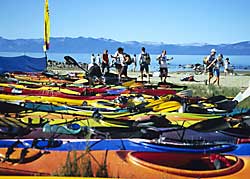
For low-stress paddling, the lakes of June Lake Loop (June, Gull and Silver), Lake Mary near Mammoth, and Convict Lake further south are popular lakes to canoe and kayak. Rentals are available at several of the lakes. The saline waters and tufa towers of Mono Lake, accessible to paddle craft on its southwest side off Highway 120 east, offer a one-of-a-kind paddle experience.
Climbing
If you don’t know that fall is perhaps the best time to visit thesport-climbing mecca of the Owens River Gorge, 30 miles south of Mammoth, and the famous boulder fields of the Buttermilks, west of Bishop (another
14 miles south), you’ve never been plastered to the rock during the height of a summer’s day in the Owens Valley.
Nestled between the Sierra and the White Mountains at an elevation of 5,500 feet, the Owens River Gorge offers dozens of excellent crags on volcanic tuff. Most of the more than 500 routes involve endurance climbing
up vertical and slightly overhanging faces with square-cut edges and incut pockets for holds. Consult Owens River Gorge Climbs by Marty Lewis for thorough descriptions of the various climbing areas and routes within the
Gorge. Wilson’s Eastside Sports in Bishop and Mammoth Mountaineering Supply are good sources of expert local information on the myriad climbing opportunities in the area.
Hot Springs
When you need a break from working your muscles, soak ‘em in one of a ‘Mother Lode’ of hot springs east of Mammoth Lakes in the valley, from unregulated and undeveloped springs like “Crab
Cooker” and “Pulky’s Pool” to the conventional public swimming pool at Whitmore Hot Springs. Most of these sites are accessed via a network of dirt roads by turning left onto Benton Crossing Road from southbound 395; keep your eyes peeled for the “little green church.” See Hot Springs and Hot Pools of the Southwest by Marjorie Gersh-Young for further descriptions and a map.
Perhaps the most interesting geothermal oddity you could ever immerse yourself in is Hot Creek (turn east on Hot Creek Hatchery Road from 395 three miles south of Mammoth Lakes). Small fissures in the streambed spew hot water into the cold main flow. Swimmers experience rapid contrasts from the hot and cold mixing. Be careful where you dip your toe – most but not all danger areas have been fenced off for those who don’t recognize that steaming vents and boiling water are scalding hot.
Sustenance
For strout coffee and a spirited vibe, visit the Loony Bean in Mammoth Lakes. For unexpectedly good grub on your way to and from the East Side, stop in at the Mobile gas station on Tioga Pass just west of the junction with Highway 395. Undoubtedly, it will be the best meal you’ll ever have from a filling station.