

- Inner Space: What We All Seek in the Great Outdoors - 06/28/2024
- Editor’s Note #132 // The Hurt Cycle - 02/15/2024
- Editor’s Note // Blessed are the frequency holders - 11/20/2023
Tahoe’s Spectacular New Bike Path
By Jason Kuchnicki
If you are an adventurist fortunate enough to have biked or hiked the Flume Trail, you know from experience that Lake Tahoe’s Crystal Bay is one of the most iconic vistas in all of Lake Tahoe. A bird’s eye view of the stretch from Incline Village to Sand Harbor State Park reveals a Caribbean-blue, boulder-bound shoreline that fades into the intense cobalt-blue offshore waters for which Tahoe is famed.
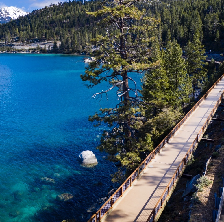
The new bike path will provide spectacular views of Tahoe’s iconic Crystal Bay. Photo courtesy of the Tahoe Fund. Photo by Michael Okimoto
However, a more up-close opportunity to experience the spectacular natural beauty of this pristine shoreline starts this week. On June 28 the East Shore Bike Path will open after a public ribbon-cutting ceremony. The paved, multiuse path begins in Incline Village at the intersection of Lakeshore Drive and Nevada State Route (SR) 28, expanding the current Lakeshore Boulevard bike path for three additional miles south to Sand Harbor State Park.
A primary component of the vision for a shared-use path that will one day go all the way around the Lake, the East Shore Path complies with American Disability Act standards, ensuring access to anyone and everyone. Along the way, access is provided to Hidden Beach, Memorial Point and various other scenic vistas. And what else would you expect to experience at Tunnel Creek than an actual tunnel? South of this point, the trail remains lakeside of SR28 for the rest of the journey to Sand Harbor.
The East Shore Path was constructed not only with recreation in mind. Significant challenges exist along the SR 28 corridor for both motorists and the large number of pedestrians and bicyclists that share the existing travel lanes and narrow shoulders during peak times. Limited parking and lack of safe, non-motorized access to popular destinations within the corridor lead to large numbers of motorists parking along narrow, mostly unpaved shoulders on the up- and downhill sides of the roadway. Demand along the corridor continues to grow, with associated shoulder-parking projected to double in the next 20 years, creating additional roadside safety hazards as well as erosion issues impacting water quality and lake clarity.
In response to increasing demand and to address and mitigate safety and environmental concerns, thirteen federal, state, and local agencies worked collaboratively to identify solutions and develop and implement an integrated approach to project design. Project goals were not only to improve recreational access within the SR 28 corridor, but also safety, mobility, and water and air quality. As a result, the implemented project has resulted in the highest possible value to the public and the greatest benefit to the environment.
The public may access the trail after the ribbon-cutting ceremony, scheduled for 3:30pm on June 28. Parking spots installed at the northern trailhead will not be immediately available prior to the ribbon-cutting ceremony. However, shuttle service transport to and from the northern trailhead will be available from Diamond Peak Ski Resort beginning at 1:15pm. Be sure to get out there and experience Lake Tahoe’s newest recreational opportunity – it’s sure to be a unique and wonderful experience.


