


Two Unknown Climbing Crags Worth Checking Out
Words and photos by Seth Lightcap
If you’re an avid North Tahoe rock climber, visiting or local, chances are you have climbed just about everything in the guidebook within your ability. The accomplishment is not too tough really. In the public’s eye there are only two major North Tahoe climbing areas: Donner Summit and Big Chief.
Looking up at the rocky peaks that surround Truckee and North Tahoe, it’s obvious that there must be countless more crags and cliffs to be climbed … But where? 
For whatever reason, the release of information about the latest North Tahoe rock climbing developments has been epically slow. The last comprehensive North Tahoe guidebook was compiled and published 10 years ago.
That’s all about to change. Next spring a new North Tahoe/Reno guidebook will be released that has double the routes of the old guidebook including several secret locations that have been kept under the radar for nearly 15 years.
To whet your palate for the swell of route beta to come, the developers of two unknown North Tahoe crags have agreed to let ASJ debut their hard work before the guidebook comes out, allowing people time to climb some fresh rock before the snow flies this winter.
Rope guns and top-ropers, locals and gapers, please welcome ‘Laddie’s Cove’ and ‘The Perch’ to your hit list…
Laddie’s Cove
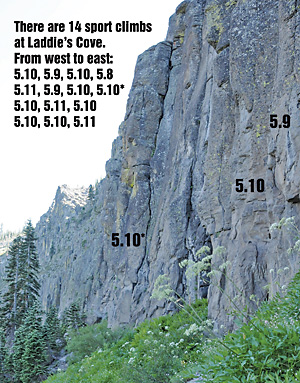
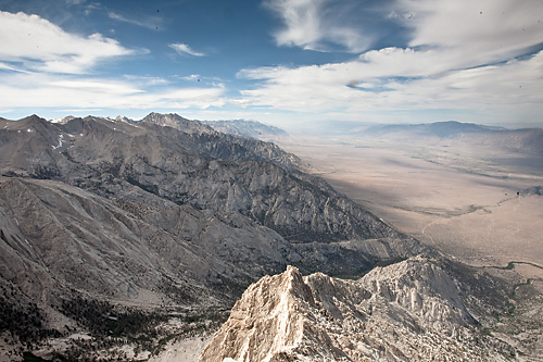
 Just south of Twin Peaks and visible from the top of Squaw’s Headwall chair, Laddie’s Cove is a north facing multi-tiered cliff band dotted with 14 one-pitch sport climbs. It’s a great new West Shore crag, but it’s by no means lakeside. Expect a nearly 45-minute drive once you leave Highway 89 south of Tahoe City and start heading west out Blackwood Canyon road.
The lower tier of the approximately 400-foot tall broken cliff band is where prolific Tahoe first ascentionist Dave Hatchett led an effort to establish a dozen plus sport routes earlier this decade. Since development, the routes have been climbed infrequently by a few locals. But the lack of traffic has had nothing to do with quality.
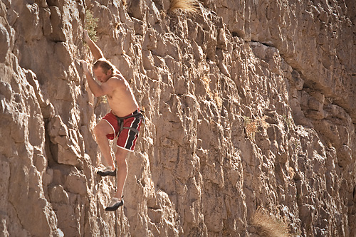
The clip-ups at Laddie’s are excellent. Varying from six to 12 bolts, the routes beeline up between vertical columns of what seems to be andesite. All the routes are moderate (three 5.11’s, eight 5.10’s, and a couple 5.9’s) and generously bolted with rap anchors at the top.
When I climbed at Laddie’s Cove in early August the routes looked like they hadn’t been touched all summer yet we found very little lichen or loose rock. That said, the routes are definitely fresh so gritty cracks and suspect holds are to be expected. Don’t belay directly below your climber out here.
Getting out to Laddie’s is fairly adventurous by Tahoe standards. The road is rough and the 25-minute approach hike is a little improbable as you drop in from on top of the cliffs. Nothing too gnarly though. Dial it in once and it will be a cakewalk.
If you’re psyched to check out Laddie’s do yourself a favor and set aside a whole day as it will take you longer than you think to get out there and back. The west-slope Sierra views are superb both driving and hiking so take it easy and soak it all in.
Directions to Laddie’s Cove:
4WD with mid- to high-clearance mandatory. A Subaru probably won’t cut it. Expect to scratch your vehicle on overgrown brush – Sierra pinstriping!
- Hwy 89 south past Tahoe City
- Right onto Blackwood Canyon Road. Follow up and over Barker Pass to the Barker Pass trailhead.
- Mileage instructions from trailhead intersection:
- 0.0 – Straight past trailhead on gravel road
- 1.3 – Straight through four-way intersection
- 3.3 – Veer right onto single lane brushy uphill road
- 4.0 – Hook left staying on main road
- 5.2 – Pass through small meadow at top of hill
- 5.9 – After three downhill switchbacks park at small pullout just before road is re-routed around big deadfall tree.
Approach:
Hike north from vehicle onto an expansive overlook. Laddie’s Cove is directly below you but guarded from above by brushy cliffs. Trend left (NW) on the plateau, hiking out and down the ridge. As the ridge tapers off and steepens look for a break in the small rock pillars that will allow you to access the base of the cliffs (3rd class). The first bolted line is 200 yards east down the cliff.
The Perch
 Tucked up past Black Wall and Stealth Wall on Donner Summit, the Perch is not an entirely new climbing area, but rather a new addition to the Donner climbing circuit.
This small cliff is very reminiscent of the ‘Greener Pastures’ crag on Grouse Slab as it is home to only five, short but sweet, moderate routes. Climbing at the Perch won’t fill a whole day, but it’s perfect for a two-hour window or paired with climbing on the adjacent cliffs.
Nobody has been keeping the Perch a secret, but it had not been climbed much, if ever, due to the horrific bushwack required to get there and the lack of fixed anchors. Both issues were generously taken care of in recent months by a motivated Truckee local who clipped a basic trail, cleaned up the routes and installed three sets of anchors.
The beauty of the Perch will be most appreciated by climbing parties looking for short moderate top-rope routes that set-up quick and offer a good progression of climbing difficulty. All five of the routes demand various crack climbing techniques but few sustained moves.
Though you could trad lead any of the routes at the Perch, the easy-to-access anchors will prompt most folks to top rope. A bushy ledge on the right side of the crag and a chimney gully on the left side both gain the top, no worries.
The three anchors hang above the most prominent lines on the cliff including 5.8, 5.9, and 5.10a cracks each with multiple starts of varying difficulty. The left most line on the crag is the easiest at 5.7 but in order to top rope it safely you must place a directional as it shares an anchor with the 5.8 crack to the right.
Getting out to the Perch is an easy 20-minute jaunt but the trail is still somewhat faint. You’ll know you’ve lost it when you’re only choice is to high step though waist-high mazanita bushes.
Until word gets out chances of running into another party at the Perch are slim. This crag should be a good bet on busy weekends for months to come.
Directions to The Perch:
- Drive up Old Highway 40 from Donner Lake and park roadside below Black Wall.
- Hike north away from Black Wall on the climbers trail that heads to Stealth Wall.
- Climb slabs in front of Stealth Wall to the top of the rise.
- Pick up a faint but distinctly groomed trail at two dead tree trunks. Trail wanders around and down through brush heading north toward a 50-foot cliff with a power line on top of it – The Perch.


Hey There, Thought you might like to know about another area in the Tahoe Backcountry similar to Laddies, in that it’s out Barker pass, but all Granite. It’s a Cliff band above the Rubicon Jeep road at observation point. The wall is massive offering the opportunity for hundreds of routes. I have been working on it off and on for 15 years. There are currently 22 routes, 18 of witch are bolted sport, one trad and a couple of top ropes in between, as well as many other top top opportunities from existing anchors. The routes vary from 5.7 to 11a with most in the .9 -.10b/c range. The trail is well cairned, leaving from the PCT about 20 min from the bear lake road PCT crossing. There is also a new area that I am beginning to get set up. It’s a wall similar in proportion to Black Wall though much broader. The walls are one hour fifteen minutes from TC driving and hiking. They are also in the process of regrading the Bear lake Road for fire protection, so the drive out will speed up considerably. I have photos, but haven’t had time to top the routes yet. They are all set with top accessible anchors for top roping, ala snowshed. Long slings or cordalettes for extending the anchors is all thats necessary. 40′ to 85′ safe but spaced bolting, not true sporty, more traditional but all well protected, especially at the cruxes. For more info, 530-721-1299
Thanks for the info Erik. Sounds like this could make a great highlight in the print edition of ASJ and/or on our site. Please email asjstaff@adventuresportsjournal.com if interested in working together with us.