 Wildlife and wildflowers add to the allure of exploring the state’s largest remaining grassland
Words and photos by Chuck Graham
At the base of the Caliente Mountains a herd of tule elk browsed across the sweeping grasslands of the Carrizo Plain National Monument, nestled obscurely in the southern coast ranges of southeastern San Luis Obispo County between the north-south arteries of Interstate 5 and Highway 101. Through binoculars I could see about 40 cows and calves munching on an array of lush, dewy wildflowers. 
I was over a mile away and had never seen elk on the plain before. With the sun at their backs I managed to close the gap to about 100 yards, running with a 300mm lens, while moving low to the ground in a shallow wash draped in tidy tips and tangled tumbleweeds.
Along with tule elk, pronghorn antelope also browse the open plain. North Americas fastest land mammal can gallop up to 50 mph crossing the grasslands between the Temblor and Caliente Mountains in no time at all. Because of these herds, the Carrizo Plain has come to be known as “California’s Serengeti.”
Natural Wonders Abound
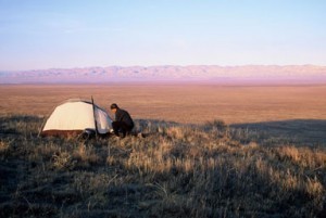
Every time I hang a left off Highway 166 onto Soda Lake Road, I’m swallowed up in the silence of this remote wilderness. The national monument turned 10 years old last April, the last of California’s historic grasslands clinging to the protection set forth by President Bill Clinton.
“It’s a unique, beautiful area,” says Jonah Hurl, resource manager of the Carrizo Plain for the past 17 years. “It’s a place where you can go without seeing or hearing anyone.”
Once I’m out here, I see something I didn’t see the time before. Late last winter my wife Lori and I saw two barn owls roosting inside an alcove of a sandstone cathedral. They flew over to the sunny side of the gritty outcropping to ward off the morning chill. They landed on a slab of sandstone covered in a montage of crimson and auburn lichen the same shades as the owl’s wings.
Another time, after heavy winter rains we were driving on Simmler Road on the eastern fringe of Soda Lake, a 3,000-acre alkaline lake in the center of the basin. We were moving slowly, careful not to get stuck in the mud, when Lori spotted a baby black-tailed jackrabbit. It was alone, separated from its mother and cold, huddling in a muddy rut. Its mottled fur was wet from the previous night’s rain and it was shivering. I pulled it out of the mud and held it close to my chest facing the morning sun. It was weeks from growing into its oversized feet and it needed a lot of luck to survive marauding coyotes and San Joaquin kit foxes that roam the plain. Reluctantly we left it behind, but it was nature’s way.
On several trips to the Carrizo Plain I’ve gone without seeing another soul. So it came as a surprise that the national monument sees anywhere between 40,000 to 60,00 visitors per year to this place off the beaten track, where the next gas station or market is 50 miles away in any one direction.
“It’s totally dependent on wildflowers,” says Hurl. “April is the busiest month. The spring of 2010 was a banner year for wildflowers.”
It’s true. Soda Lake Road runs for 50 miles through the Carrizo Plain, and in 2010 the Temblor Mountains to the east and most of the grasslands were splashed in swaths of purple, yellow, pink and gold.
Golden Hour
It was a lung-busting ascent at dawn, rising above the floor of the Carrizo Plain, achy legs churning my mountain bike up Caliente Mountain, San Luis Obispo County’s highest summit at 5,106 feet. I left the sweeping grasslands and lost myself in the oak woodlands while pedaling up Caliente Ridge for a different perspective and taking in the vast expanse of the plain.
Aside from old cattle ranching roads and remnants of ranches dating back to the 1940s, the Carrizo Plain suffers from very little human impact. In fact, ravens and raptors have taken over those weather- beaten manmade structures and made them into their own. Old windmills, water tanks and teetering barns are fair game for annual nest sites.
My eyes were tearing up in the frigid 20 degree temperatures and my lungs burned with each deep breath. It was silent except for my huffing and puffing. Gratefully I pulled up to a natural overlook to catch my breath as shadows retreated across the sweeping plain.
As I neared the summit at the top of the ridge, I spooked a majestic golden eagle roosting in a gnarled oak tree. It swooped over me and continued east out over the grasslands vanishing against the stark landscape of the Elkhorn Plain in the southeast corner of the monument. What would take me half a day’s ride, hell, the raptor was already there.
Soda Lake
The flock of American avocets skimmed the surface of Soda Lake maybe a millimeter separating their wing tips from the shimmering shallows. They gathered inside a tiny cove sharing it with a bevy of sandpipers and long-billed curlews.
Soda Lake is the largest natural alkali lake in California and during wet winters attracts migrating sandhill cranes. During the dry season Soda Lake becomes a blinding white, 3,000-acre salt pan, the midday glare seen from miles away. But at sunrise and sunset the edge of the lake is one of the more tranquil places across the Carrizo Plain. It’s a place to wander and reflect. It’s also good time to see some of the 180 bird species that frequent the national monument.
The best place to do this is along the boardwalk that meanders along the west shore of the alkali lake, a good place for setting up a spotting scope or scanning with binoculars. Shorebirds and geese fly in by the hundreds, Soda Lake being part of the Pacific Flyway, the lonely, wide open expanse a safe haven for flora and fauna alike.
Back on Highway 166 unfortunately signaled the end of another Carrizo Plain experience, leaving behind the grasslands, soothing silence and too many natural wonders to count. That is until once again I feel the tug inside to pack up my truck and climb Highway 33 to return once more to “California’s Serengeti.”
________________________________________________________________________________________________________________________
Getting There: Northbound exit off Highway 101 in Santa Maria to Highway 166 heading east for 60 miles. Turn left on Soda Lake Road. Southbound take Highway 101 and exit onto Highway 58 in Santa Margarita. Head east for 50 miles and turn right on Soda Lake Road.
Camping: There are two free campgrounds, the KCL Campground and the Selby Campground. Potable water is available. Bring all food and gear. Next available facilities are 50 miles in every direction.
For more information: www.blm.gov/ca/st/ en/fo/bakersÞeld/Programs/carrizo.html