


May blizzards put a freeze on the Tour of California, but summer promises pleasant riding in Tahoe — honest!
By Tim Hauserman
Mother Nature has been far from hospitable to cyclists in Tahoe this year.
Most publicly, she had the audacity to drop snow and frigid temps on the opening two days of the biggest cycling race in North America, the Amgen Tour of California, nixing Tahoe’s debut performance on the world cycling stage with an icy middle finger.
But really that’s just egalitarian treatment for the pros. She’s been downright surly with nearly all Tahoe- region cyclists and visitors this spring. Mountain bikers are still waiting for the dirt to appear on many of their favorite trails. And roadies have had to endure an unsettled spring that’s been more of an extension of winter than a prelude to summer. Many just gave up and went skiing. 
But now, finally, Ma Nature has put out the “Welcome to Summer” mat.
The peaks are still snow-capped but the snowplows are idle. The riding is beautiful. Come up and experience what the Amgen Tour peloton unfortunately missed out on.
Here are some good road routes to consider in the North Tahoe-Truckee area. Studded tires not required:
Blackwood Canyon
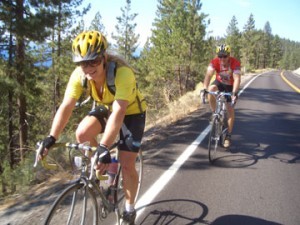
Barker Pass Road, which heads up Blackwood Canyon on Tahoe’s northwest shore, feels like a mountainous Tour de France stage without the screaming fans. Steep and narrow, it dishes out some kick- ass vistas across Blackwood Canyon to Twin Peaks.
The journey begins with an easy two-mile spin to a pastoral crossing of Blackwood Creek. Then the climbing begins, with a 1400-foot ascent in five miles to the end of pavement at the Ellis Peak trail (another half mile on dirt takes you to the PCT). It’s a steady low-gear grunt, followed by the long and winding ride back down.
The road isn’t plowed, so it takes until late spring or early summer to be snow free — count on the latter this year; it might even be July. But a few weeks before it is fully melted, you can ride the first few miles car free. Even once the road is open to cars, it is not exceptionally busy. Primary users are hikers heading to trailheads, so expect traffic early morning going up, and late afternoon going down.
To begin: Kilner Park, a good starting point, is three miles south of Tahoe City on Highway 89. You will find restrooms and water. From here, ride the bike trail two miles to Barker Pass Road and head up the canyon. To shave four miles, you can begin at the junction of Barker Pass Road and Highway 89.
Tahoe City to Truckee
This is a popular ride in both directions, often to access other rides, such as Donner Lake and Lake Tahoe.
From Tahoe City, proceed along the Truckee River bike trail to Squaw Valley. Early in the morning, late in the afternoon, or during the off-season this is a quiet, lovely ride along the Truckee River. Mid- summer, mid-day it is an obstacle course of oblivious, rafters and walkers, rarely paying attention, and small children just learning how to ride.
Past River Ranch things clear out and the riding is very pleasant to Squaw Valley. At Squaw, you can take a two-mile side trip into the valley or continue toward Truckee on Highway 89. The highway is busy, but the bike lane along the side is generous, and at least on the way to Truckee, you have the river clearly in view much of the way.
Eight miles from Squaw, you reach the outskirts of Truckee and a turn around spot just before the stop-light. Many riders swear that the section between Squaw Valley and Truckee is uphill in both directions, due to the barely detectable grades and swirling winds.
To begin: From Tahoe City, go south 1/4 mile on Highway 89, turn right into the “64 acres” parking lot, the Truckee River Recreation Trail and Public Access lot, and begin riding. From Truckee, ride down Highway 89 from wherever you are. Parking is available just 100 yards south of the light at West River Street. Restrooms and water are available at the Squaw Valley Park.
Donner Lake to Cisco Grove
It’s 40 miles and a deceptively difficult classic that should be on every Tahoe road rider’s tick list. From the east end of Donner Lake, start out riding west on Donner Pass Road. After a two-mile pleasant warm-up along the lakeshore, you are ready for the three-mile climb up Donner Pass. It’s generally not that steep, but if you need to catch your breath there are plenty of awesome Donner Lake views along the way.
At Donner Pass, you begin a long gradual descent to Cisco Grove. In a big snow year like this, you’ll enjoy the frothy waters of the South Yuba River tumbling later than usual, especially just above Rainbow Lodge, where the river frantically cascades down granite boulders.
Your turn around is at the Cisco Grove private campground where the road ends. As you start heading back you discover the deceptively difficult part of this ride. Was the hill this long and sustained on the way down?
When you finally crest the summit and fly down the winding road back to Donner Lake, take a sharp right turn at the bottom of the hill onto South Shore Drive and follow it around the lake to road end at Donner Memorial State Park. Here a bike trail continues into the park, quickly dumping you at a lovely beach calling your sweaty name for a dip. Cleanse and revive. It’s only a short coast to the park entrance and your car.
To begin: From Truckee, take Donner Pass Road west to parking on the road side near the entrance to Donner Memorial State Park. Water and restrooms can be found at a boat launch near the western end of the lake.
Boca to Stampede
For a fun 20-mile ride, start at Boca Reservoir and pedal along the Little Truckee River on a moderate uphill to Stampede Reservoir. After the steepest section, you reach a left turn, which takes you on a several mile jaunt over the dam and along the shore of Stampede to the boat launch.
To add a few miles, before you turn to go over the dam, continue ahead for several miles until the road junctions and pavement ends, then turn around and come back to the dam crossing road.
The ride provides wildflower dotted meadows, access to two reservoirs, and relatively easy riding on a lightly traveled road. Just like Jackson Meadows, the traffic you do see, however, is likely to be big and pulling a boat.
To begin: Drive seven miles east of Truckee on Interstate 80. Take the Boca-Hirschdale Road exit. Head over the railroad tracks to a small parking lot above Boca Reservoir. No bathroom or water facilities available at the start, but campgrounds along the route provide both.
Jackson Meadows Reservoir
This 36-mile out and back is a little known biking prize that is well worth a look. Long gentle descents and ascents bring you past quiet forests, wildflowers, and expansive views of Perazzo Meadows.
Your turn around point is Jackson Meadows Reservoir, a pleasant surprise that feels like Donner Lake without the houses crowding the shoreline. The road shoulder is narrow, but traffic is light, especially mid-week. What traffic you do see, however, will probably be a monster pickup hauling a power boat and coolers of beer in a hurry to get to the lake, so keep your ears peeled.
Got an extra day? Camp at Jackson Meadows, then jump on the little used, but beautiful section of the Pacific Crest
Trail which goes right through camp. Foot- traffic only.
To begin: Drive 14 miles north of Truckee on Highway 89. Turn left onto Forest Service Road 07, where you immediately find your starting point at a parking area with pit toilets (no water).
Sierra Valley
The Sierra Valley provides some of the best riding around. Start out by riding much of the route of the Tour de Manure metric century. From Sierraville head west about five miles on Highway 89 to Sattley, then turn right onto
A-23. Spin through lovely level countryside 16 miles to Highway 70, where you turn right.
In just a few miles, turn right again onto A-24 and travel through the center of the valley some 16 miles to Loyalton. From here, take a right and in 13 miles you will have looped back to Sierraville.
To begin: Drive 25 miles north of Truckee on Highway 89. Where 89 and Highway 49 meet in Sierraville begin your ride. Find water and restrooms in Sierraville and Loyalton.
Tour de Manure, June 11: Looking for a summer warm-up century? This is a great one. You only have to ride the more civilized 62 miles of a metric century, and there is excellent food and camaraderie at the end. Benefits Sierraville Fire & Resue. $45 until June 8; $55 after. Register at active.com.
_________________________________________________________________
Tim Hauserman lives in Tahoe City and wrote the guidebook to the Tahoe Rim Trail.


Tim,
I don’t know when the last time you went out Bear Valley Road to Jackson Meadows Reservoir. But there are expansion cracks every 20 to 30 feet, some as wide as 4 inches. I got 2 miles out and gave up because of the bike-jarring crashes every few seconds. Big disappointment!
Hi Mark, Thanks for the comment and updating our readers on road conditions. This article was originally published in the summer of 2011, so our guess is this was based from 2010 or earlier.