Dropping into Tenaya Canyon
By Aron Bosworth, Outdoor Project
Yosemite National Park is well known for the awe-inspiring granite formations that tower overhead, crooking the neck of visitors and drawing in climbers from around the globe. Lesser known, however, are some of the natural features that beckon from below. One such descending feature is the rugged chasm known as Tenaya Canyon, an infrequently travelled granitic trench of glacial-carved bowls and eroded gorges that connect the Yosemite Valley floor to the park’s high country at Tenaya Lake, by way of Tenaya Creek. 
As a canyoneering route, Tenaya Canyon is an exciting, demanding endeavor offering a level of solitude that is difficult to find in other areas of the park. Canyon descents provide unique perspectives on notable landmarks such as Half Dome, Clouds Rest, the Quarter Domes and Mount Watkins. The polished granite open bowls of the upper canyon provide striking contrast to the jagged, boulder-lined slot canyon of the deeply eroded gorges below; together the terrain raises the bar on ruggedness typically found on a day trip.
Tenaya Canyon also holds a reputation for being dangerous, and it is full of terrain that is difficult to navigate. Hikers should not set out in the canyon on casual exploratory outings. Lives have unfortunately been lost here. As a deterrent, the Park Service has posted signs warning unprepared visitors against venturing on.
The Tenaya Canyon descent is considered a technical canyoneering route (3B IV, three stars by the American Canyoneering Association) that requires critical route finding, climbing/canyoneering gear, creek and pool fording, and multiple rappels. The route starts at 8,200 feet and drops approximately 4,200 feet over ten miles, requiring off-trail navigation over creek crossings, talus fields, steep exposed granite slabs, boulder-lined gorges, wet rocks, ledges, and cliff drops. Four drop-offs ranging from 30 to 70 feet, each equipped with rappel anchors, are found within a section called the Inner Gorge. The climbing gear needed includes a 60-meter rope, a helmet, webbing/slings, climbing harnesses, a rappel device and carabiners, and essential backcountry safety gear you shouldn’t leave home without. The ability to treat water for resupply is also helpful.
The ACA rating details the route as taking a long day; experienced canyoneers should be able to complete the route in ten hours. Tenaya Creek runs the length of the canyon, so the route is more easily navigated during low summer flows. Setting up a car shuttle the night before on the valley floor at Trailhead Parking is key.
The Route
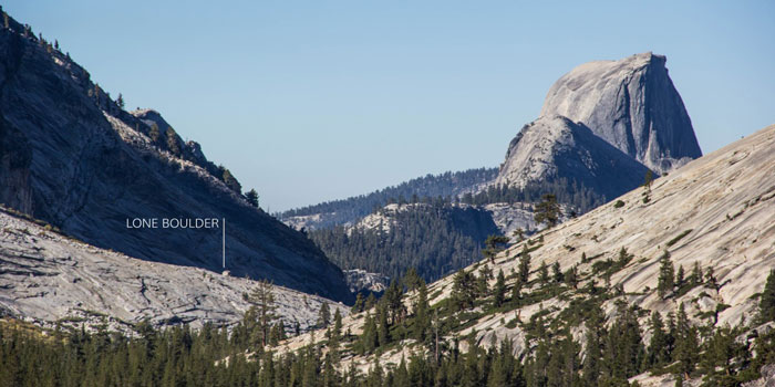
Upper Canyon + Lone Boulder
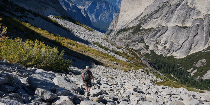
The 3.5-mile upper section of Tenaya Canyon from the Sunrise Trailhead to the navigational marker known as Lone Boulder is relatively tame terrain compared to the steep slabs and gorge that lie below. Off-trail beyond the first half-mile, much of the terrain is flat and easy to navigate. Downhill sections of the upper canyon are mild and the talus fields minimal. The key to this section is locating Lone Boulder beyond the first forested valley while descending the upper granite bowl, as it gets lost once in the valley. Lone Boulder is the navigational aid that positions parties for the more critical route finding ahead.
Steep Rock Slab Descent + Lost Valley
This section drops from Lone Boulder, bypasses Pywiack Cascade, and proceeds down the safest possible route, a 700 foot line down a steep rock slab, to reconnect with Lost Valley below. Leaving Lone Boulder the route trends left down talus fields and bushwhacks through a dense brushline. At a second bush patch the talus becomes solid rock and marks the area of descent down the slab.
A solitary fir tree marks the descent route to the bottom with little room for route-finding error due to the slabs exposure. Parties should be able to spot the best approach and avoid any unexpected ledges or steepening. Toward the bottom of the slab, more bushwacking leads to the lone large fir tree.
The route then continues down to a pool along Tenaya Creek and into Lost Valley, the descent’s second picturesque cradled forested valley.

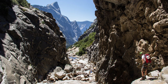
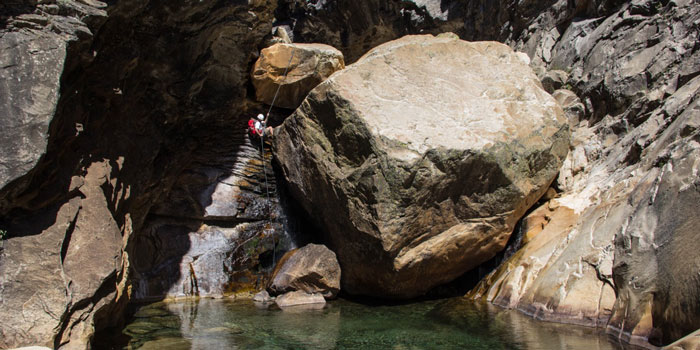
The Inner Gorge
Beyond Lost Valley the canyon forms a narrow “V” as it drops gradually toward the Inner Gorge, the dramatic boulder-lined slot canyon that holds multiple ledges and four exciting rappels. Boulder hopping and scrambling over the van-sized boulders is the norm here, and progress in the Inner Gorge can be slow. The rule of thumb is to stay right as nearly all navigational aids, rappel anchors, mandatory downclimbs, tunnels, and bushwacks are on the canyon’s right-hand side.
The four rappel points along the route are found within the Inner Gorge. The first and third anchors are located along right-side ledge terraces and drop 45 feet at the start of the gorge, and 70 feet towards the middle of the gorge, respectively. The second rappel surmounts LeConte Boulder, a massive boulder blocking passage early in the gorge, and drops down a waterfall into a crystal clear pool. The fourth rappel is more of an aided descent down a sloping rock located between a series of emerald green pools. Between the second and third rappel, look for a keyhole tunnel through a group of large boulders that appear to form another barrier in the canyon.
Lower Canyon to Mirror Lake
And just like that, following the fourth rappel, the Inner Gorge opens up to a much broader lower canyon approximately 5.75 miles from the trailhead. The route continues down the stream bed, stays right and up along the eroded cliffs above Tenaya Creek, eventually finding use trails that connect to the Mirror Lake Loop. The mile and a half beyond the Inner Gorge remains rough terrain that only eases up on the Mirror Lake Trail. At a footbridge, the route intersects the eastern portion of the Mirror Lake Loop as it turns back to the Mirror Lake Trailhead at the intersection with Happy Isles Loop Road. From here parties can either walk back to Trailhead Parking a mile away or catch the free valley bus to pick up the shuttle car that was dropped previously on the valley floor.
Note: This information is only an overview and is not intended to serve as a guide through Tenaya Canyon. More detailed information including photos can be found at outdoorproject.com.