Hotlum-Wintun Ridge: A California Classic
Words and photos by Aron Bosworth
If you have driven Interstate 5 through Siskiyou County, you’ve likely found your gaze pulled toward the glistening white of 14,197 Mount Shasta. It’s difficult not to: Shasta’s summit is striking. Rising 10,000 feet above the northern California landscape, the mountain is both alluring and awe inspiring. Indeed, thousands are compelled to attempt to climb Mount Shasta annually.
Mount Shasta’s call beckons to backcountry skiers as well. Skiing off Shasta’s summit can be likened to a rite of passage for the California ski mountaineer. For many, the taxing climb and exhilarating ski become an annual pilgrimage.
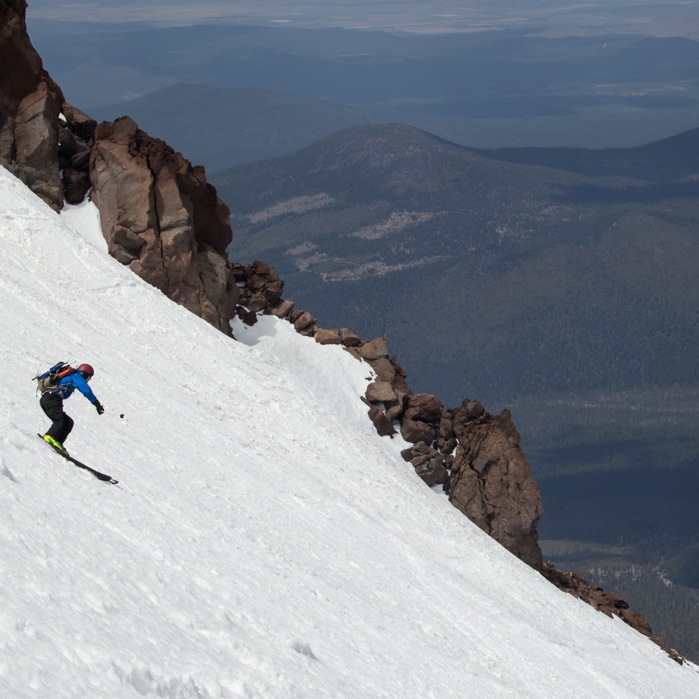
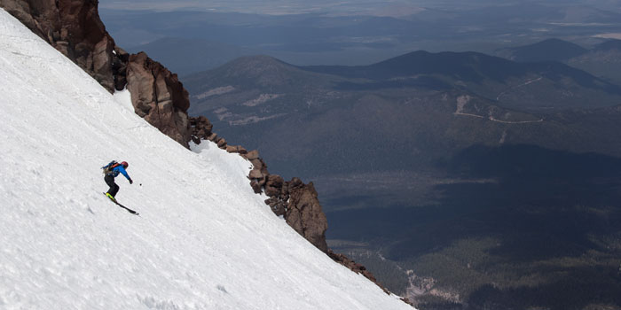
As the second-highest peak in the Cascade Range and the fifth-tallest in California, Shasta offers some of the longest ski descents in the state. One of these, located on Shasta’s eastern aspect, is the Hotlum-Wintun Ridge. Rewarding the skier with nearly 7,000 feet of vertical descent, 4,000 feet of which is sustained 40-degree (and slightly steeper) skiing, Hotlum-Wintun is one of California’s finest runs and a ski mountaineering classic by any standards.
Beyond the draw of the vertical, Hotlum-Wintun offers a descent that tends to ski well during lean snow years (which is crucial for recent winters) and is a relatively safe route that lacks crevasses, fumaroles and significant rockfall hazard. Located on the quieter east side of the mountain, Hotlum-Wintun also sees substantially less climber traffic than the popular and often over-crowded Avalanche Gulch route that begins at Bunny Flat on Shasta’s south slopes.
While the Hotlum-Wintun Ridge can be completed in a long day with an early alpine start, there are advantages to completing the climb and ski in an overnight, not the least of which is allowing fresher legs for the objective’s highlight: the descent. A bench around 9,800 feet affords a comfortable base camp to break up the climb.
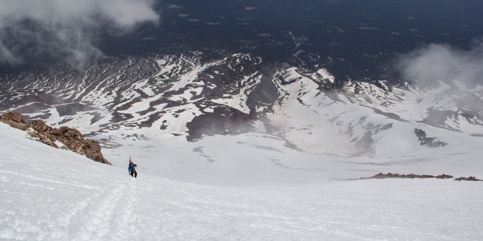
Though it is called a “ridge,” the Hotlum-Wintun Ridge route doesn’t actually stay on a distinctive ridge; rather, it ascends a large snowfield that separates the Hotlum and Wintun glaciers for much of the route before traversing onto and above the Wintun Glacier. The ideal season to ski the route is typically between late April and early June when winter avalanche hazard has subsided and prime corn snow forms as part of the daily freeze-thaw cycle. Keeping a close watch on the weather with a keen eye for cold, freezing nights and sunny, relatively warm, light wind days at higher elevations will set you up for optimal conditions. Always carry a map, compass and GPS, and the knowledge to use them, in the event weather limits visibility and route finding.
The Route: The Hotlum-Wintun Ridge route is considered Grade II. A rope isn’t necessary, but crampons and ice axe are a must. Skiers should ensure their self-belay and self-arrest skills are up to snuff, as a fall near the summit where the route is steepest could result in a long and dangerous slide, particularly if firmer snow is encountered near the summit. It is best to time a descent for no later than midday to ensure quality corn snow; if conditions are too warm, as can happen in the early afternoon, the snow can turn to heavy slop below 12,000 feet.
The Hotlum Wintun Ridge begins on the east side of the mountain at the Brewer Creek Trailhead, located at 7,300 feet. Depending on timing, snow may extend below the trailhead, ending car access and requiring a skin up the road to the trailhead. If snow reaches down to the trailhead, skin westward through tree line, and aim towards Shasta’s summit. If the snowline is higher than the trailhead, hike the Brewer Creek Trail along its southward track until you encounter snow. It’s a good idea to mark the trailhead with a GPS waypoint if this is your first time on the route, particularly if snow extends to the trailhead covering the Brewer Creek Trail. Skiers will not be able to see the car through the trees on their descent.
With either approach, the route emerges above tree line, following the low-angled slopes south of the adjacent Brewer Creek drainage, which is formed by a large moraine on the right. Ascend to the bench around 9,800 feet. If you are planning on setting up base camp, this rocky bench has good sites. Brewer Creek flows adjacent to the north, and it is typically open by mid-spring. Check with local outdoor shops or the ranger station on current water access. If you are climbing earlier in the season or are unsure whether the stream will be accessible, bring extra fuel to melt snow for drinking water.
The Hotlum-Wintun Ridge ascent is easily discernable from the bench as it heads straight up the large snowfield above. Skin or hike 2,400 feet up the snowfield in the direction of the spine of rocks that divide Wintun Glacier from the snowfield, trending left. The seracs and crevasses of Hotlum Glacier should remain far to the right on the other side of the snowfield. Continue climbing to the traverse located at a grouping of rocks known as Lunch Rocks. This is where climbers/skiers traverse south below a buttress to a wide chute directly above Wintun Glacier and a recommended spot to put on crampons.
The route becomes steeper above the traverse, exceeding 40 degrees in spots. It’s a bootpack from here on out. Climb 2,000 feet of steep terrain, a phenomenal pitch for the descent to come. Continue up the wide chute to the summit.
The ski descent follows the same wide chute that you previously ascended. Either traverse back to your ascent route at Lunch Rocks and descend into the large snowfield via the traverse, or opt for a steeper and more consistent pitch that drops down the Wintun Glacier to around 10,200 feet. If you descend the Wintun Glacier, inspect and plan your traverse back across the Hotlum-Wintun Ridge to the snowfield above camp. Take care not to drop too far down toward the Ash Creek drainage or you’ll be skinning out. There typically are a couple of navigable snow ribbons that cut across the ridge and connect the Wintun Glacier and the snowfield.
The upper 4,000 feet of consistent, steep corn skiing and the spectacular views and dramatic scenery of Mount Shasta make this one of California’s best. Enjoy the turns, and ski back to camp (or car) via the lower section of snowfield. This is a California classic not to be missed.
Logistics: Summit passes are required on Mount Shasta for anyone climbing above 10,000 feet. They cost $20 and can be purchased at local ranger stations in Mount Shasta City or McCloud, at local outdoor shops, or at the self-issue stations at trailheads. Free self-issue wilderness permits and human-waste packout bags are also required for overnight stays in the Mount Shasta wilderness. Both can be obtained at the trailhead.

Aron Bosworth is cofounder and chief adventure officer at Outdoor Project, an online resource and social community combining field guides and maps, inspiration and planning information to provide the absolute best resource to plan your next outdoor adventure. Learn more about Mount Shasta and other adventures at outdoorproject.com.