Mt. Tamalpais Stinson Beach – Pantoll Loop Hike
Story and Photos by Haven Livingston

Choosing a day hike from the myriad options in Marin County can be a serious challenge. One route that seems to make most local’s top pick list is the Matt Davis-Steep Ravine-Dipsea Loop from Stinson Beach. It’s great any time of year, you just have to pick the right day. With the coastal climate of Central California you might get drizzled on in June and have a sunny sweat fest in January. Each season serves up its own bonus from spring wildflowers to winter waterfalls.
Starting the 7.3-mile hiking only trail at Stinson beach has the advantage of ending with a downhill, but starting at the Pantoll Ranger station is also an option. Either way you’ll be going downhill one way and up the other. From the Matt Davis trailhead on Belvedere Avenue, just past the fire station in Stinson, the trail immediately begins to climb. It’s a moderately strenuous trail. If you need an excuse to take a break, there are plenty of thimbleberries to stop and pick in early summer. 

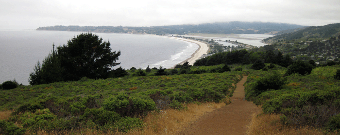
About one mile up, a rocky outcrop called Table Rock is a cool place to take a break and take in the view of Stinson Beach. Climb through a jungle gym of well worn California Bay Laurel branches to reach the top of the rock. If you set out on a foggy day the views may be disappointing, but the trail scenery is beautiful and diverse the entire route.
After a couple of miles the climb graduates from a canopy of bay laurel to more open Douglas-fir forest until arriving on the nose of a grassland ridge. From here, the trail levels out and contours in and out of incised ravines revealing waterfalls during the rainy season. After four miles, the trail pops out at the Pantoll Ranger station.
From Pantoll there are many options to extend the hike. For an extra 4.3 miles through mixed hardwoods and chaparral, continue from Pantoll up the Old Mine Trail to Riding and Hiking trail to Easy Grade trail that ends near the Mountain Theater. From the Theater, take Rock Spring Trail to West Point Inn. Walking downhill to the right, circumventing the Inn, a flat spot with shaded picnic tables has unobstructed views of Old Railroad Grade and the fire lookout on Tam’s summit. Nora Trail heads downhill from the picnic area and connects with the Matt Davis Trail to return to Pantoll.
Once back at Pantoll, the scenery shifts and redwoods appear along the creek as Steep Ravine Trail dives back down to the Pacific. Winter Wrens serenade hikers passing cascading waterfalls deep in the ravine. This short one mile section intersects with the Dipsea Trail where hikers hang a right into rolling coastal scrub to return to Stinson. Along this wide open pathway, sweeping vistas of Stinson beach come into view before the trail descends beautifully constructed staircases to Highway 1.
Mount Tamalpias State Park has over 50 miles of hiking and biking trails and the Park connects with a larger, 200 mile trail system.
For info about Mount Tamalpias State Park go to: http://www.parks.ca.gov.