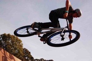
California’s Dynamic Cascade Duo
Be a backcountry ski superhero this spring with back-to-back descents of Shasta and Lassen
Story and photos by Brennan Lagasse

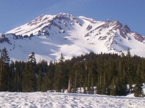
- Mount Shasta’s Avalanch Gulch from the Bunny Flat trail head.

When John Muir first summited Mount Shasta he swore he could see the Pacific Ocean more than 100 miles
away. While today’s air quality might not be as consistently clear as when Muir first stood atop the rime spackled summit of this Cascade Range giant, at 14,179 feet you’re bound to get some memorable views so long as you don’t climb this weather catcher when it’s shrouded in clouds.
While you can attempt the summit of Mount Shasta year-round, the months of April, May and June provide the most consistent snowpack and the most reliable chance for optimal weather. If you’re a skier or snowboarder you’ll probably be in the minority of those attempting a summit on a clear day as for most people the goal is just to get to the top. But when everyone else is walking down, you’ll be sliding down one of the longest, most incredible spring runs found anywhere on the planet. 
Mount Shasta is one of the largest stratovolcanoes in the world. When visibility is good, the mountain can be seen for more than 100 miles in all directions. Since it rises well over 10,000 feet above the town of Mount Shasta whether you’re approaching the peak from the north, south, east or west, the magnitude and sheer mass of this looming mountain is enough to induce a little dashboard delirium.
“When I first caught sight of it over the braided folds of the Sacramento Valley,” wrote Muir, “I was fifty miles away and afoot, alone and weary. Yet all my blood turned to wine, and I have not been weary since.”
But keep your eyes on the road and continue to your trailhead of choice. Depending on the time of year, snowpack and road access, prime trailheads will be one of many accessible entry points on the north (North Gate), east (Brewer Creek), southeast (Clear Creek) or south/southwest (Bunny Flat, the most popular) side of the mountain.
______________________________________________________________________________________________________________
“Time a descent of Mount Shasta right and you’ll quickly become one of the many who swear this is the best ski descent in all the lower 48.”
______________________________________________________________________________________________________________
Shasta has seven named glaciers and is one of the only spots in California where a ski mountaineer can encounter crevasse and glacier travel. Being such a monolith of a peak, a massive cone dwarfing the surrounding landscape and reaching into the Pacific jet steam, Shasta also has the tendency to create its own weather. This is why the mountain sees so much more traffic in the spring when ice, snow, and weather conditions are typically much more favorable for an ascent and descent. If you’re ever climbing Mount Shasta and notice clouds forming, especially lenticulars, your best move might be to head back to lower elevations and wait for more ideal weather.
However, time a descent of Mount Shasta right and you’ll quickly become one of the many who swear this is the best ski descent in all the lower 48. Yes, you read that right — not just California, but the whole continental U.S. If you take into

account the ample snow the mountain grabs through winter, the amazing vertical relief that offers the chance to easily tag a 7,000-foot descent and sometimes even 9,000 feet, and top it off with generally mild weather, you have the ultimate recipe for a backcountry skier’s dream come true.
And unless you want to practice your mountaineering skills for bigger mountains abroad, you don’t even have to deal with the crevasses or glaciated terrain. Most people bent on summiting Shasta start from the southwest trailhead at Bunny Flat and a good majority of backcountry skiers do as well. From here, most climbers and skiers head directly up Avalanche Gulch, recently named one of the “Fifty Classic Ski Descents of North America,” though other options exist, such as Cascade Gulch to the north and Green Butte Ridge to the south.
Sure, some of the other ski routes on the north and east side have a more classic type of appeal, and you’ll leave the crowds in an instant, but timing up a perfect corn run down the West Face Gully (looker’s left of Avy Gulch) or Trinity Chutes (into Avy Gulch) in Grade-A corn with a consistent pitch for more than 7,000 feet is tough to beat.
There are numerous ways to ascend and descend Mount Shasta. Generally, the routes on the north and east sides are more technical, while access from the southwest is fairly straightforward. When accessing Shasta from the southwest via Avy Gulch be aware of the hordes of other people you may be sharing the mountain with on a weekend, the potential for rock fall, and again, any signs of instable weather.
It’s also a good idea to assess your level of fitness before attempting a route on Mount Shasta. Some parties take up to three days to acclimate properly, ascend, and descend. Others break the trip into a two- day overnight affair, while some of us prefer the light and fast method of leaving the car in the dark with a headlamp or perhaps under a full moon and busting out the 7,000- plus foot ascent in one smooth push.
I like to head up when I know the mountain is in a spring corn cycle and weather seems like it’ll be clear during the day with a good freeze at night. Start early. My take is that it’s always better to wait on top for the snow to soften than be rushing to ski down before things turn to slop.
______________________________________________________________________________________________________________
“My preference is usually either a descent of the West Face due to the consistent pitch and reliable snow consistency, or the steep Trinity Chutes … You just need to find the right entrance and slide on in.”
______________________________________________________________________________________________________________
A typical Avy Gulch route attempt might have you showing up to the Bunny Flat trailhead where you can sleep in your vehicle or throw out a quick tent for the night in the parking lot. Don’t forget to buy your Summit Pass, get a Wilderness Permit, and grab a human waste packout bag (or two!), all conveniently found at the kiosk right next to the two pit toilets at the trailhead or in town at the Forest Service office.
If you estimate you can ascend about 1,000 vertical feet an hour, you can do the math as far as when you want to be on top and dropping in. Generally, even the most fit athletes feel the effects of altitude above 12,000 feet so don’t forget to factor that into your equation. I’ve left as early as 2 a.m. so as to not rush my way up, but have had just a good of a run and still summited leaving the car at 5 a.m.
The route winds up from the Bunny Flat trailhead past Horse Camp on to Helen Lake at around 10,000 feet. This is where you’ll usually switch from skinning to crampons and ice axe mode for the rest of the climb. From Helen Lake, there’s

usually a long, long, long bootpack that takes a line near what’s known as the Thumb and up past the Red Banks. Once you’re past the Red Banks the altitude starts to kick in, especially on Misery Hill and the final slog to the summit.
Mount Shasta’s summit is somewhat unique; a nipple-like feature protruding off the high summit plateau. These final few hundred vertical feet are often not very skiable and typically consist of some of the funkiest snow mixtures one could imagine.
If you happen to look down the east facing routes, between the Wintun and Hotlum glaciers, toward the Brewer Creek Trailhead, you’ll quickly add another ski route to your list.
But your car’s at Bunny Flat so it’s time to make a ski call: Do you descend Avy Gulch, the West Face, or the Trinity Chutes? Of course there are other more exposed options on this side of the mountain as well, such as those found off Sargents and Casaval ridges, but the former three runs are classics and line up the best for consistently good skiing.
My preference is usually either a descent of the West Face due to the consistent pitch and reliable snow consistency, or the steep Trinity Chutes. When timed right, the West Face offers one of the most enjoyable corn runs imaginable. However, if you’re a chute skier and like to get “walled” then you’ve already scoped out the Trinity Chutes on your climb up Avy Gulch; they’re just above “The Heart” and to the left of Red Banks. Now you just need to find the right entrance and slide on in.
Mount Shasta is not only one of the greatest skiable peaks in the lower 48, it’s also a mountain that begs the attention of many other types of people drawn to it for a diversity of reasons. Those that look past Shasta as a ski descent still find profound meaning in the mountain based on its sheer beauty and innate sacred qualities.
Several Native American tribes believe Shasta is the center of all creation and the local Wintu Tribe still performs ceremonies here each year to help continue the flow of water in a local sacred spring. Many “New Age” people have been drawn to the Mount Shasta area believing Mount Shasta to be a spiritual source for peace and harmony in the world and an epicenter of some sort of huge energy vortex.
Whatever the draw, Mount Shasta is truly one of the most special mountains in the world. From the headwaters of the Sacramento River in the bucolic little Mount Shasta City Park, one mile north of downtown, where you can drink fresh volcanic-filtered spring water right where it bubbles up, to the diverse inhabitants of the town itself, to the best corn skiing on the planet, this Cascade gem is a must for those who are really looking to earn their turns (and beer!) this spring.
______________________________________________________________________________________________________________
“While the 2,000-foot runs that fall off the south face are worthy enough, it’s the possibility to climb the south side for 2,000 feet and ski down over 4,000 feet to the Devastated Area that’s the focus of most avid backcountry skiers.”
______________________________________________________________________________________________________________

Mount Lassen
However, if you really want to earn your beer you’ll link up the classic California Cascade duo and hit a ski descent of Mount Lassen before you head out of the area and back to your low-altitude reality.
For some unfounded reason, Mount Lassen often escapes the radar of many passionate backcountry skiers and ski mountaineers. This is thanks in large part to the multiple routes and sheer magnitude of its bigger, more attention-getting sibling we just talked about. But even though the vert may not be as great, Mount Lassen can offer up just as good skiing as its bigger brother.
Rising to 10,457 feet, a descent of the northeast face of Mount Lassen is tough to beat. In the winter access is brutal since the south entry to Lassen National Park is closed due to snow, but once the Lassen Loop road opens the easy shuttle run offers up one of the finer runs anywhere in California. While the 2,000-foot runs that fall off the south face are worthy enough, it’s the possibility to climb the south side for 2,000 feet and ski down over 4,000 feet to the Devastated Area that’s the focus of most avid backcountry skiers.
Simply start at the summit parking area and follow the summer trail to the top of the peak from the south. The relatively easy climb takes little time and the long descent down the northeast aspect is more than worth the effort. The gullies that make up the northeast face avalanche regularly so caution is advised. However from the top you can spot a rib in the middle of the face that allows you to stay out of the potential terrain trap the gullies represent.
It’s best to get an early start when linking up this classic shuttle run as warm springtime temps will often soften the snow and make it perfect for snow sliding as early as 11 a.m.
To link up the northeast face shuttle run leave a car at the small pullout at the base of the Devastated Area and continue driving or hitch a ride to the summit parking lot for the ascent up the south side of the peak. There are a few variations to ski with a run down the southeast, north ridge, or northeast face being the main three objectives.
If you’re looking for a little more spice find the short but sweet entrance to a small notch splitting the sub peak to the riders right of the main summit. Some route finding and down climbing may be necessary to access this little gem, but the few steep turns in perfect corn snow will be worthy for those wishing for the adrenaline that accompanies this descent.
Linking up ski descents from the summits of Mount Shasta and Mount Lassen in a weekend is something motivated California backcountry ski mountaineers should add to their list to achieve honorary superhero status. While much effort, knowledge, and precaution must be taken before embarking on such an adventure, it’s tough to find a more rewarding two-day ski adventure than ticking off two major classics on back-to- back days.
Of course, if you’re not up to taking on the challenge of skiing these peaks back-to-back, they each make a worthy destination in and of themselves. They’re also two peaks that will make you want to spend more time on each of them. There are numerous ways to descend them both and the terrain, scenery, and the new friends you’ll make is uncanny and a rite of passage for California-based skiers and riders.
A true superhero, after all, is always ready for the next challenge.