


Paddling the state’s only major undammed river is good reason to explore California’s Del Norte County
By Haven Livingston
There is a treasure in far northwestern California that goes unexplored by most who pass through it. It is the intrepid and curious outdoor wanderers who have found this gem and placed it where it belongs: upon the crown of California’s wild places.
Continuing northward from Humboldt County through the forests of towering redwoods and across the Klamath River brings you into Del Norte County (pronounced “Del Nort” by the locals). Few Californians are familiar with our northern most coastal county, probably because Del Norte is home to much more wilderness than people. Those who do know about it recognize it for its magnificent old growth forests, historic lighthouses, or the expansive crescent beach in Crescent City. A rare few are intimately familiar with its inner secrets.
Stepping east from the sparsely populated coast reveals a treasure you won’t find anywhere else in the Golden State: The only major undammed river in California from source to sea, the Smith River.
Draining the western slopes of the Siskiyou Mountains of California and southern Oregon, the Smith River is a wonderland watershed. During and just after the rainy season it is a destination river for whitewater kayakers and rafters. All three forks of the river have navigable runs and countless tributaries make for exciting steep-creek boating. Summertime brings warmer water for leisurely tube floats and swimming during the dry season’s low flows.
An undammed status in California is reason alone to celebrate a river, but the Smith has plenty more attributes to boast. In 1990, 450 square miles of the Smith River watershed within the Six Rivers National Forest was designated as a National Recreation Area (NRA) for protection of wild and scenic rivers, ecological diversity and recreation opportunities. More than 320 miles of the Smith River and its tributaries are designated wild and scenic, making it the longest river in the National Wild and Scenic Rivers system. It is considered the premier stronghold for wild salmon and steelhead in the state and is a world-renowned fishing destination.
In the words of Six Rivers National Forest Biologist Mike McCain, it is a “land of superlatives” with the largest redwood tree, the state record for the biggest steelhead ever caught, the highest rainfall in the lower 48’s to fall in one year (20 feet!), one of the most diverse coniferous forests in the world, and the list goes on.
Remarkably, none of the above facts were what kept this author coming back year after year to kayak the Smith.
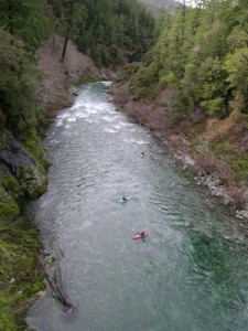
Undeniably, the most appealing feature of the Smith River is the water itself. It is some of the cleanest water in the world. The river receives very little sediment due to the basin’s geology and the intact surrounding forest. Metamorphic rocks comprise the canyon walls and serpentine is one component of the basin. Sunlight penetrates through the clear water and reflects the blue and green hues of the serpentine giving the river an otherworldly aquamarine color. Even after a heavy rainfall the water will return to its clarity within a couple of days. That clarity makes kayakers feel as if they’re floating on air because they can see through the gin clear water to the bottom of the river below their boats.
Paul Gamache and Jennie Goldberg are two kayakers who hold a special place in their hearts for the Smith. Goldberg has seen plenty of rivers in her 30 years of paddling and competing in both slalom and wildwater racing. She’s held national and world titles, been to Olympic team trials twice and has been an American Whitewater board member since 2000. While living in Seattle for graduate school she was introduced to the Wild Rivers Coast of Southern Oregon and Northern California and discovered the Smith River. Goldberg lives in Seattle now and still makes the trek down to paddle the turquoise flows.
She loves it for the same primary reason everyone else does. “It’s beautiful and well worth the 10-hour drive from Seattle,” she says. “It’s got it all: easy runs, moderate runs, challenging runs, all within the same basin, and in some sections you’re paddling through these incredible old growth forests with giant trees.”
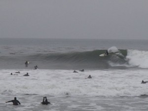
Gamache may be best known for his 2008 world-record setting drop down a 108-foot waterfall in British Columbia (since broken, but no less impressive), but his 2006 run through Oregon Hole Gorge on the Middle Fork Smith at flood stage may be even more impressive to experienced kayakers. Just days before, the river had flowed at 450 cubic feet per second (cfs), a level you could easily wade across. With nonstop rainfall the flow charged up to 80,000 cfs carrying entire trees down with it and swallowing the banks of the river whole. The gorge was a veritable firing squad with gaping holes, whirlpools, re-circulating eddy lines and no escape with the edges of the river rising well into the surrounding forest.
Gamache put into the river alone while his two friends drove back downriver to film what they hoped would not be his last run. Fear is palpable in their recorded voices as they beg Gamache to roll up again and again and again, for a massive total of 11 rolls in less than the 2 minutes it took to get through the roughest one-mile section. He took an incredible beating, but repeated the mantra his buddy said to him while getting ready, “Whatever you do, do not swim.” A swim, purposefully exiting the kayak due to the inability to roll upright, could be a fatal move with the tremendous force of the floodwaters, untold submerged debris, potential for entrapment, and the fact there was no one else on the river to help.
Paddling this section wasn’t in the initial plan for the day, but Gamache saw the opportunity and took it, and to this day is still thankful he did it and made it out in one piece. Today, Gamache’s new exploits on the Smith involve a project called Explore Six Rivers (www.exploresixrivers.com). This project will see Gamache’s team float down each of the six rivers within Six Rivers National Forest from their source to the sea. The six rivers include the Smith, Van Duzen, Mad, Eel, Trinity and Klamath Rivers.
Gamache’s flood-water run is an example of the most extreme of the whitewater possibilities on the Smith. The three forks of the Smith sport a variety of runs, which, depending on the water level, can be appropriate for everyone. The runs don’t end with the three forks though; Hardscrabble and Goose Creeks are two of Gamache’s favorite tributary runs and there are at least 12 others of varying difficulty. Gamache recommends Lars Holbek and Chuck Stanley’s book, The Best Whitewater in California, for more detailed information. Other good info sources can be found online, including A Wet State (awetstate.com) and California Creeks (cacreeks.com).
The Middle Fork Smith boasts the most variety of difficulty starting with a casual class I-II lower section that is frequented by locals in tubes and pool rafts toting an extra tube for the cooler. This fun run starts at the iconic ‘Forks’ where the South and Middle Fork come together. It passes Jedediah Smith State Park Campground, with great riverside camping and redwood giants right in your campsite, it is a first choice for many campers. During the low-water period the park install a footbridge to cross from the campground into the Stout Grove of ancient redwoods on the opposite bank. The beach leading to Stout Grove is a bonus stop for river runners offering a great lunch spot and a sun-speckled walk through the giants.
The Middle Fork’s class II-III middle section is perfect for beginning kayakers and tubers alike and starts at the confluence of the North and Middle Forks (which is a location that doubles as a great summertime swimming hole). The classic IV+ two-mile Oregon Hole Gorge is in between the previous two runs and ends with the Oregon Hole Rapid.
Another Middle Fork run from Patrick Creek to Panther Flat serves as a nice warm up for the North Fork with more gradient and technical drops than the South Fork. If you can master this run, you’ll be in control on the North Fork. The Siskiyou Gorge, another class IV-V run, is in the upper reaches of the Middle Fork above Patrick Creek. Scouting most of the Middle Fork is a cake walk with Highway 199 following it all the way into Oregon.
The South Fork is well known for a fun and easily accessible 11-mile class III (with one IV) run between Steven’s Bridge and Craig’s Beach. This run probably sees the most diversity of craft between rafts, hard shell kayaks and inflatable kayaks. If you don’t take out at Craig’s Beach you’ll be heading into the class IV+ South Fork Gorge. This gorge has more difficult and continuous drops than the Oregon Hole Gorge and a more remote feel. Goldberg and her friends often like to take a day to “gorge out” as she calls it. They run all of the short, challenging gorges in one day because they are all so close together and easy to approach. In all the gorges the difficulty and challenges can vary greatly with the water level, so homework is required to find out what you’ll be facing.
The North Fork stands apart as a classic class IV wilderness run for 14 miles. It is a favorite to both Goldberg and Gamache for its remote wild feel. The North Fork does have the longest drive at about two hours, but you can maximize your time by calling local Bearfoot Brad in the town of Gasquet for a shuttle: (707) 457-3365 or email bradcamden@earthlink.net. He’s been running shuttles for over 20 years on the Smith and charges the reasonable rate of $45/shuttle. He’ll be able to give you tons of local beta and your vehicle will be safe and secure in his driveway if you want to make the trip an overnighter.
North Fork canyon has its own unique geology and is home to the Darlingtonia pitcher plant, whose carnivorous ways attract insects with sweet nectar before trapping and devouring them. Beautiful waterfalls and fun rapids make the long drive worth the run. In comparison to whitewater in other parts of the state, Gamache says, “Paddlers in central and southern California won’t get this where they are. Out here on the North Fork you will have the whole river to yourself. There is no road next to the river, it’s wilderness.”
Goldberg recalls one trip on the North Fork during high water. “It only took us 45 minutes. Normally that’s an all day run. It was a blast!”
High water is a phenomenon that is easy to predict since the Smith has no dams and is primarily rain fed. All you have to do is watch the weather and know that when it rains, the river rises. This makes the Smith one of the earliest runnable rivers in California. Paddling season can begin as soon as the fall rains drop, often in November, and run all the way through May and even early June in some years. There is no need to wait for the Sierra snowpack to start melting before you can paddle, but you had better bring a dry suit and hot chocolate! A mid winter run can be frigid with the cold water and chilly air temps.
A trip to the Smith River can easily fill 3-4 days of great kayaking or rafting. Add a few days on to that to slide down the nearby Cal Salmon and Trinity Rivers and a trip to California’s north coast can really pack in a lot of paddling.
“There’s a lot of bang for your buck with all the runs here on the Smith,” says Gamache. “There is very little driving involved in paddling many sections of the Smith, and that’s not something you always get with a trip to the Sierra.”
Great paddling, an outstanding river, and hardly another soul around. What are you waiting for?


[…] and is a world-renowned fishing destination. … … Read more from the original source: Discovering Smith River Country « Adventure Sports Journal ← Fall Sale Thru October 10th | Alder Creek Kayak & Canoe […]