Exploring the mythic Lost Coast of California
By Leonie Sherman • Photos by Mario Courbis
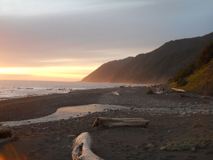

You can’t get lost hiking the Lost Coast. To the west the heaving pounding thrashing Pacific ocean stretches to Japan, fading into foggy depths of gunmetal gray. To the east, dramatic dark mountains thrust skyward, sheer walls of crumbling mud. Hemmed in by impenetrable cliffs and the unfathomable sea, the narrow boulder strewn beach is the only path. Long stretches are swallowed by rising tides twice a day. With no cell reception and no way out, the stakes are high but the rewards match the risk. This is the wildest, most remote section of California coast, and it’s available to anyone who’s willing to shoulder a pack.
“Lost Coast” refers to the roadless section of Northern California’s shore that stretches from the mouth of the Mattole River to Usal Creek. Three tectonic plates meet here at the Triple Mendocino Junction; the Pacific Plate is moving north, relative to the North American Plate, while the Gorda Plate is diving underneath the continental crust. The geologic processes move too slowly for us to observe, but the results are clear: steep terrain, violent upthrust and severe erosion. Kings Peak rises from sea level to 4,087 feet in less than three miles. The San Andreas fault has its northernmost landfall along this stretch of coast.
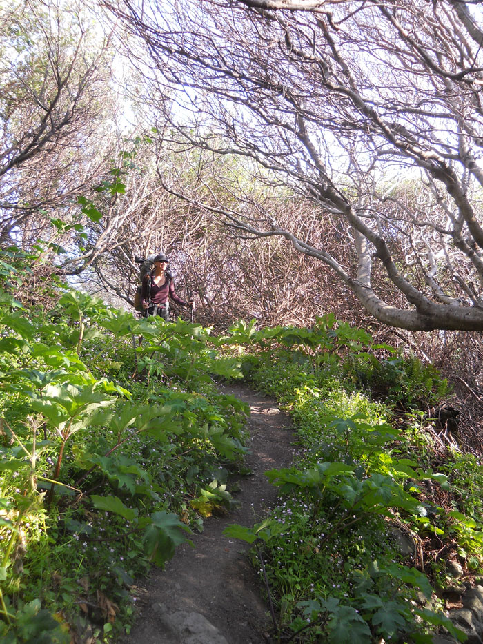
My partner and I planned to explore the Kings Range Conservation Area, the northern part of the Lost Coast. Our hike followed the coast for almost 20 miles before veering inland. Next we’d tackle the Buck Creek Trail, climbing 3,000 vertical feet in three and a half miles to the summit of Saddle Mountain. From there we’d hike 25 miles north along ridge tops back to our vehicle. After our first high camp, we’d hike 20 miles of deep forest and dry chaparral with no water source.
When I read the words “beach walk” I imagine sand between my toes. But the coastal section of the Kings Range Conservation Area features second class scrambling over slick boulders and fields of ankle rolling rocks. I hiked 30 miles along the edge of the Monterey Bay barefoot in January, but wore my burliest boots to hike the Kings Range in April.
And April is the premier season for this hike. Magnificent Roosevelt elk graze on coastal prairies. Wild salmon spawn up cascading creeks; we watched a pair patiently dig a redd to lay eggs. Douglas Iris blooms paint wide swaths of blue and purple across verdant hillsides and meadows. Bears prowl the beach at dawn and dusk, sniffing for food and potential mates. This is the most popular time on the route and hikers congregate at the few level campsites along creeks above the tide line.
Years ago I hiked the southern section of the Lost Coast, Sinkyone Wilderness State Park, during February. In three days we saw two people. Blue-eyed grass and lupine dotted the hills. Our first night we camped at an abandoned homestead, beneath blooming stone fruit trees, next to feral tulips glowing in the setting sun. We supplemented our dinner with wild greens and barked back at curious harbor seals on a desolate beach.
Sometime during that first night, a front moved in. Wind clawed at our tent while rain and hail pounded our puny shelter. The next morning the trail was a river of sludge. Top soil poured off the hillsides, entire sections of trail collapsed, and thousands of feet below us the ocean roared, eating away at the base of cliffs and hills. Unseen tectonic forces buckled and thrust the earth’s crust upwards. Though we grumbled about wet socks and clammy rain gear, we also got a front row seat to the epic battle between land and sea.
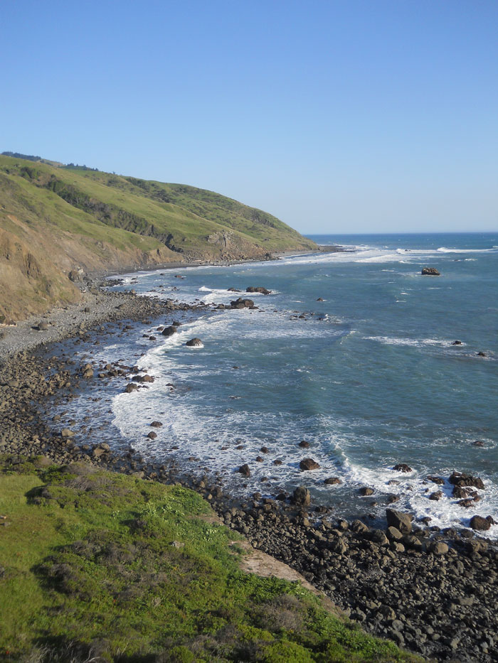
You can experience a slightly less dynamic version of coastal geology during a sunny day in April, hiking south from the mouth of the Mattole River. Low dunes give way to steep coastal terraces. After three miles, the decaying Punta Gorda lighthouse looms over the shore. Decommissioned in 1951 after only four decades of operation, the lighthouse was named “massive point” after the promontory on which it stands.
Along 24 miles of coast in the Kings Range, three sections are designated “impassable at high tide.” Conventional wisdom suggests skirting these sections within two hours of low tide. This feels like a logistical hassle until you pause just north of the lighthouse and realize that “impassable at high tide” means a cliff drops straight into the ocean. Rising waters quickly devour the thin margin of boulder strewn black sand. When you’re hiking any coast-line, “Impassable at high tide” is not a suggestion, it’s a commandment. Honor those who have come before by learning from their mistakes.
During our two days of coastal hiking, low tides occurred around sunrise and sunset. We cursed our 5am reveille, until realizing we we were the only travelers in the pre-dawn stillness. A full moon provided enough light to hike by and cast spooky shadows on the beach before slipping beneath the horizon at dawn. We were mesmerized by gleaming ripples on the gently lapping ocean. A bear appeared through the gloom and ambled south before heading inland.
As we passed Randall Creek, the dusky violet of night gave way to clouds streaked with light. By the time we reached Rattlesnake Creek the sun was overhead and we were ready for a siesta as we waited for the next low tide. I resolved to drag myself out of bed earlier while backpacking so I can appreciate the transition of night into day and earn a fat afternoon nap.
That evening we built a driftwood bonfire at Gitchell Creek and watched the sun sink into an ocean of shifting light. I strummed my ukulele as my partner cooked dinner and we howled at the rising full moon, before the gurgling creek lulled us into gentle dreams.
The next morning we headed for the interior after bidding farewell to the heaving ocean and barking seals. The Buck Creek Trail is shrubby and desolate as it winds through spiky chaparral and dense forest. Relentless switchbacks offer sweeping panoramas of placid ocean, precipitous green hillsides and crystal clear skies. At the summit we turned north onto the crest of this most violent and stunning coastal range. We skirted badly eroded sections of trail and marveled at trees with exposed roots clinging to sheer hillsides. The interior, though lashed with over a hundred inches of precipitation each year, is a dry desolate place. We didn’t see another person until we left the wilderness.
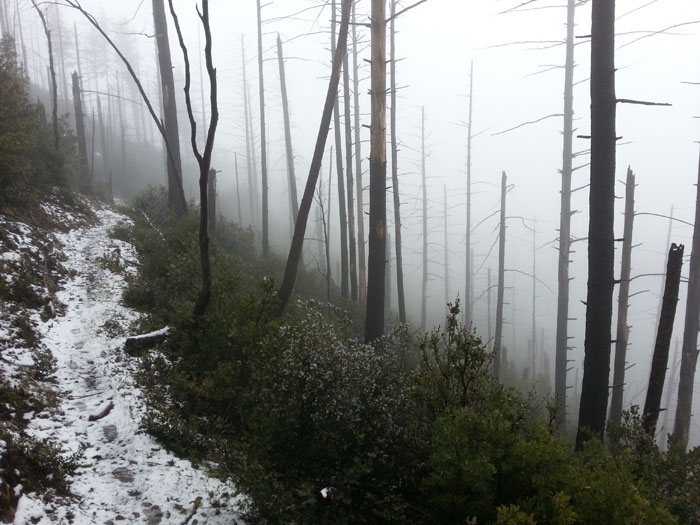
On our last morning we woke to an inch of snow. Dark branches gleamed under their frosty flocking. My companion’s belongings lay in a puddle at the foot of his sodden sleeping bag. Our breath hung in the air as we discussed options. A ten-mile hike to the nearest pavement was the quickest exit, and once we started hiking, mud and snow discouraged breaks. We were at the road by early afternoon and the third car to pass brought us back to our vehicle.
We paused at the parking lot with gulls wheeling overhead and the distant rumble of the surf filling our hearts. A trip into the back country along California’s wildest shore left us reverent and contemplative. We departed with salt on our cheeks and a wistful nostalgia for the days when all of coastal California was wild.